
 KPTV Fox 12 Oregon
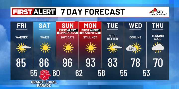
It reached the low 80s yesterday in the metro, and even warmer in the upper 80s east in the Gorge and south in the valley near Roseburg. Along the I-5 corridor, highs were in the upper 70s. Coastal spots topped out in the upper 50s to low 60s.
The upper-level ridge continues to build today. Expect warmer afternoon highs in the mid-80s through the metro and south valley, low 80s in southwest Washington, and low 90s east in the Gorge. Along the coast, expect mid-60s to low 70s.
As the core of hot air shifts directly over us Sunday and Monday, those refreshing ocean breezes will come to a complete stop. That means highs will soar into the low to mid-90s. We’ve now included Monday as a First Alert Weather Day, with cooler westerly winds not expected to return until later that evening. Get re

 Darkhorse Press
 KPAX
KPAX KSLA News
 Associated Press Top News
 FOX Business Video
 FACTS.NET Sports
 The Washington Post Politics
 CBC News World
 Daily Star Weird News
 IMDb TV
 E Online
 AlterNet