
 Idaho News 6
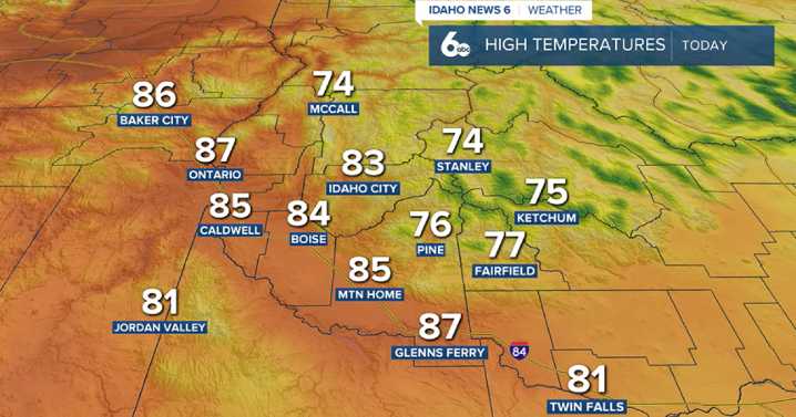
Idaho News 6
After a rainy Wednesday, a shift in the weather pattern is underway. A ridge of high pressure is starting to build over the area, slowly pushing the moisture northward and drying things out. While we won’t be completely storm-free just yet, the chance of showers and thunderstorms will be much lower today and Friday. Expect a 20% chance of isolated storms, mainly in the higher terrain of southeast Idaho and parts of west-central mountains. These storms won’t be as wet as previous days — the main impact will likely be gusty outflow winds.
By Saturday, the upper-level ridge will strengthen further, bringing even drier and more stable conditions. Skies will also turn a bit hazy through Friday, as upper-level winds bring in smoke from wildfires burning in western and central Oreg

 Local News in New York
 KRIS 6 News Weather
 KPTV Fox 12 Oregon
 FOX 10 Phoenix National
 Boston.com News
 FOX 5 Atlanta Crime
 Newsday
 AlterNet
 Newsmax TV