
 USA TODAY National
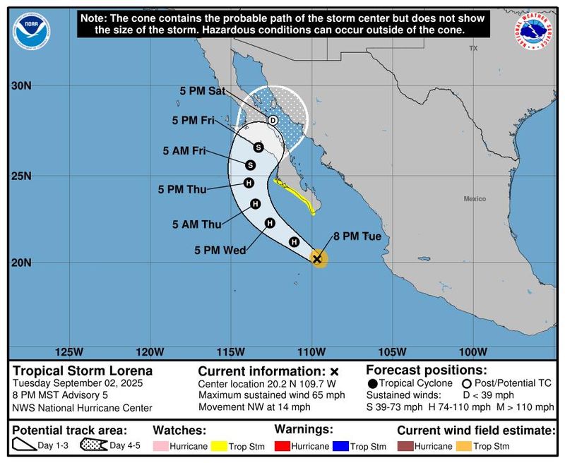
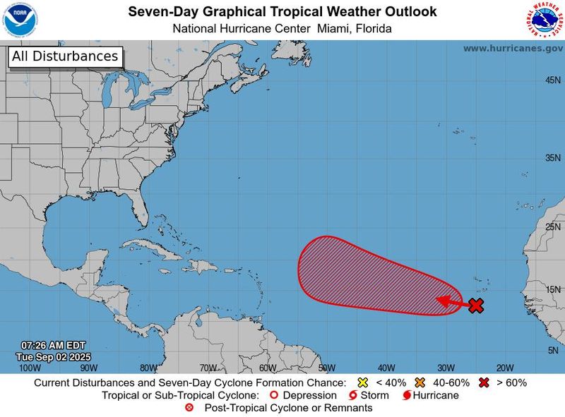
September has arrived with news that the National Hurricane Center is watching a new tropical storm off the southwest coast of Mexico, and a westward-moving tropical wave far out in the Atlantic Ocean shows increasing chances of becoming a tropical cyclone.
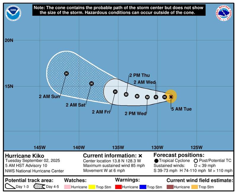
Meanwhile, Hurricane Kiko, further west off Mexico's coast, is strengthening in the Pacific.
The most immediate concern is Tropical Storm Lorena, about 185 miles south of Cabo San Lucas, and about 260 miles west of Cabo Corrientes, Mexico. Lorena may rapidly intensify and is forecast to become a hurricane on Sept. 3, for at least a brief period, the hurricane center said in an 11 p.m. ET update.
Lorena has maximum sustained winds of 65 mph and is moving northwest at 14 mph.
Tropical Storm Lorena could become Hurricane Lorena
The government of Mexico has issued a tropical storm watch for the west coast of Baja California Sur, from Cabo San Lucas northward to Cabo San Lozaro. A watch means tropical storm conditions are possible within 48 hours.
Lorena could potentially bring "significant flash flooding" to locations in the region, the hurricane center said. Interests in southwestern Mexico and Baja California Sur have been advised to monitor Lorena's progress.
Bands of heavy rainfall are expected to reach the Baja Peninsula by Sept. 3 and southwestern Sonora by Sept. 4, the hurricane center said. Rainfall totals of 5 to 10 inches are expected, with maximum amounts up to 15 inches, across portions of Baja California Sur through Sept. 5.
The hurricane center said uncertainty remains and "locally higher or lower amounts are possible depending on the track and strength of the system."
A surge of moisture ahead of Lorena could drop up to 2 inches of rain or more over the northwest Mexico states of Colima to Sinaloa and northward into Arizona through Sept. 5, the hurricane center said, creating a potential for isolated to scattered pockets of flash flooding.
The storm is forecast to peak with maximum sustained winds of about 105 mph, then begin to weaken as it approaches landfall along the Baja Peninsula. The center's forecast shows a potential landfall over central Baja on Sept. 5, but differences remain among the models used to guide forecasts.
Lorena is forecast to dissipate over the weekend as it crosses the Gulf of California and reaches mainland Mexico.
Could another Atlantic storm form?
The tropical wave in the Atlantic, now south of the Cabo Verde Islands, is producing disorganized showers and thunderstorms, but environmental conditions continue to be favorable for a tropical depression to form later in the week as it moves across the eastern and central tropical Atlantic, the hurricane center said. At 8 a.m. on Sept. 2, the hurricane center put the chances of development at 70% over the next seven days.
The next name up for the seventh storm of the Atlantic hurricane region is Gabrielle.
What else is in the Pacific?
Hurricane Kiko, about 1,700 miles east of Hilo, Hawaii, has reached maximum sustained winds of 105 mph as it moves westward at about 7 mph. It's forecast to continue strengthening with peak sustained winds reaching as high as 115 mph by Sept. 3. Its five-day track shows no indication of a threat to land.
Dinah Voyles Pulver, a national correspondent for USA TODAY, covers climate change, weather, the environment and other news. Reach her at dpulver@usatoday.com or @dinahvp on Bluesky or X or dinahvp.77 on Signal.
Contributing: John Bacon
This article originally appeared on USA TODAY: Hurricane Kiko forms off Mexico's coast; forecasters watch 3 systems
Reporting by Dinah Voyles Pulver, USA TODAY / USA TODAY
USA TODAY Network via Reuters Connect

 The Washington Post
 The Oregonian Public Safety
 AccuWeather Severe Weather
 Gainesville Sun
 WCBI-TV
 El Paso Times
 Raw Story