
 USA TODAY National
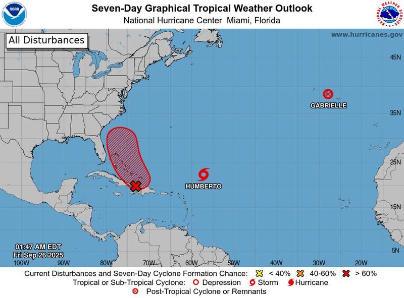
The tropics are officially alive, finally, and may be stirring up trouble for the Southeastern coast of the U.S.
A tropical wave moving in the Caribbean Sea is likely to become Tropical Storm Imelda by the weekend as it moves into the Bahamas, and it's increasing the likelihood of potential impacts along the U.S. coast, according to the National Hurricane Center. Meanwhile, Humberto has become a hurricane northeast of the northern Leeward Islands and is forecast to continue strengthening.
Humberto is forecast to become a major hurricane later on Sept. 26 or on Sept. 27, the hurricane center said. If it does so, Colorado State University hurricane researcher Phil Klotzbach said the Atlantic would be "3 for 3" in hurricanes becoming major this year, with Erin and Gabrielle both becoming major hurricanes.
The last time an Atlantic hurricane season's first three hurricanes reached that level was in 1935, he said.
How the storms interact with one another and with other weather systems in the region will determine the extent of impacts the storms could have on the U.S. East Coast, the Bahamas and potentially Bermuda over the next few days, but the risks are growing for impacts along the coast between Florida and North Carolina, hurricane center director Michael Brennan said on the evening of Sept. 25.
Forecast for Caribbean tropical wave
An area of low pressure is expected to form along the tropical wave in the Caribbean as it moves near the southeast Bahamas, the hurricane center said early on Friday, Sept. 26. "This low is expected to become a tropical depression when it is in the vicinity of the central and northwest Bahamas late Friday or over the weekend and then track northwestward or northward over the southwestern Atlantic."
"There's an increasing risk of impacts from this system across portions of the Bahamas and across portions of the Southeast United States coastline as we go through the weekend and into early next week," Brennan said on the evening of Sept. 25.
Uncertainty remains in the track forecast for the wave, with the models meteorologists use to forecast the storm's track are divided about its eventual direction. The models show chances of the wave moving very near the coast or possibly making landfall in the Carolinas, as well as chances of it veering out over the open Atlantic as other storms have done this season.
"Interests in the Dominican Republic, Haiti, the Turks and Caicos Islands, and the Bahamas should monitor the progress of this system. Regardless of development, heavy rains and gusty winds are likely across that region during the next couple of days," the hurricane center said. "While there is significant uncertainty in the long-range track and intensity of the system, the chances of wind, rainfall, and storm surge impacts for a portion of the Southeast U.S. coast are increasing. Interests in that area should monitor the progress of the system."
In addition, "the system could also pose a heavy rain and flood threat to the Carolinas, southern and central Appalachians, and Mid-Atlantic regardless of development and even if it stays offshore next week," said WPLG-TV hurricane specialist Michael Lowry in a Substack post Sept. 25.
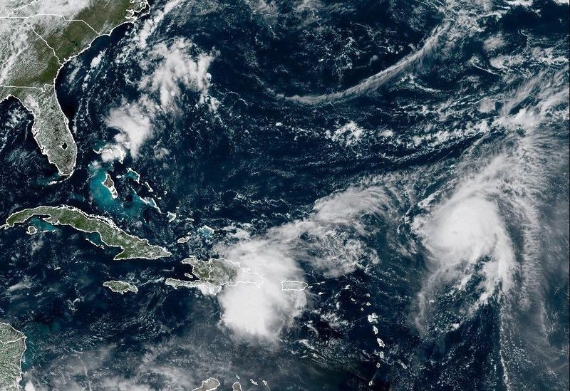
Flooding was reported in Puerto Rico on Sept. 25, according to the weather service.
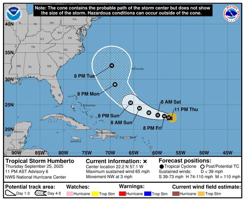
Humberto forecast to become major hurricane
At 11 a.m. on Sept. 26, Humberto was centered about 450 miles northeast of the northern Leewards and moving northwest at 5 mph, with sustained winds of 90 mph.
For now, Humberto is forecast to follow a pattern similar to Erin, moving between the U.S. and Bermuda, but the strengthening Humberto is increasing the risks of long period swells that could make seas and surf hazardous along the U.S. coast, the hurricane center said. Humberto's exact track is uncertain and remains tied to the future of the potential Imelda and other weather systems in the region.
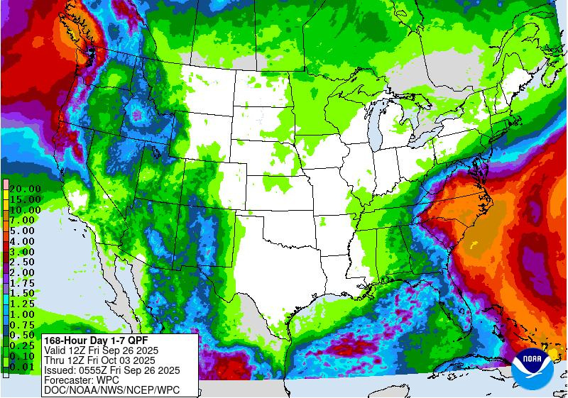
Rainfall maps from the National Weather Service Weather Prediction Center have increased the potential rainfall that could occur in the Southeast over the next seven days.
Track the path of Humberto, other Atlantic systems
This forecast track shows the most likely path of the center of a storm, not the full extent of the storm or its impacts. The center of a storm is likely to travel outside the cone forecast up to 33% of the time.
Doyle Rice and Dinah Voyles Pulver are national correspondents for USA TODAY who have written about hurricanes, violent weather and climate change for decades. Reach them at drice@usatoday.com or dpulver@usatoday.com.
This article originally appeared on USA TODAY: Humberto strengthens to hurricane; forecast warns of rising risk for parts of US
Reporting by Doyle Rice and Dinah Voyles Pulver, USA TODAY / USA TODAY
USA TODAY Network via Reuters Connect

 FOX 51 Gainesville Crime
 Law & Crime
 The Fayetteville Observer
 WSVN 7 News
 People Human Interest
 Breitbart News
 FOX 13 Tampa Bay Crime
 Index-Journal
 CBS4 Miami
 9&10 News