
 WYFF Greenvile
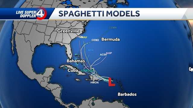
The Southeast needs to stay alert as we continue to watch a tropical wave (Invest 94L) that will most likely become Imelda.
Several models for Invest 94-L now show a direct path from Charleston → Columbia → Greenville/Spartanburg along Interstate 26., early next week.
Hurricane Stats
Spaghetti Models
At this time, the European models indicate this system will strengthen into Tropical Storm Imelda. However, the GFS shows a potential Category 1 hurricane.
Hurricane Track
The stronger and more organized the storm (Invest 94L) gets Friday, the more likely it will be to impact South Carolina.
The weaker and more disorganized the storm stays, the more likely it is that Humberto grabs the circulation and sends it out to sea.
Possible impacts in Upstate South Carolina:
Monday – Tuesday (T

 Sarasota Herald-Tribune
 The Daily Beast
 Essentiallysports Football
 AlterNet
 Essentiallysports Basketball
 Reuters US Politics
 PennLive Pa. Politics