
 WITN-TV
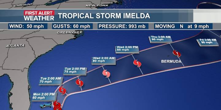
The WITN First Alert Weather continues to keep a close eye on Tropical Storm Imelda as the storm tracks through the Bahamas.
Imelda’s sustained winds have eased up to 50 mph Monday Morning. The latest track and model data continue to show Imelda taking a hard turn to the east Tuesday morning and tracking away from the US coast. Cloudy and breezy conditions with periods of rain will be likely across eastern NC Monday and Tuesday. Gusty winds will stick around into Wednesday as well.
The forecast track shows Imelda remaining a tropical storm as it heads north offshore of Florida. Once it reaches parallel to Cape Canaveral, FL, it’s expected to turn right out into the Atlantic, potentially strengthening to a Category 1 hurricane. The trend south will keep the worst of the wind and rain out

 ClickOrlando
 WDSU New Orleans
 WSAV
WSAV Local News in Florida
 Associated Press Top News
 The Weather Channel
 CNN Climate
 KSNB Local4 Central Nebraska
 WLOX
WLOX FOX Carolina
 Crooks and Liars