
 KIMT News 3
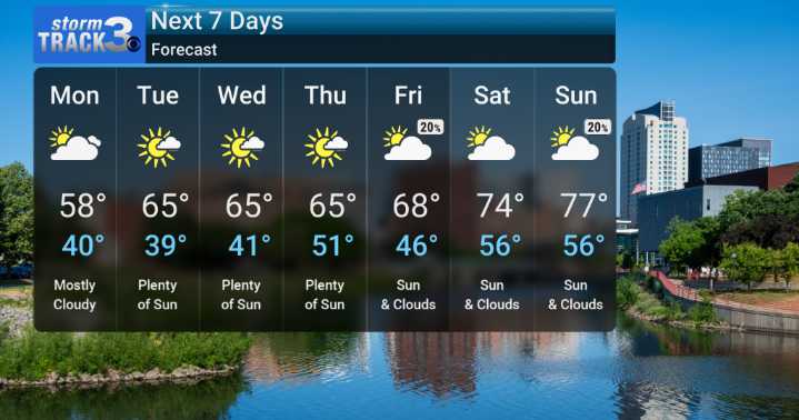
As we move into the new work week, we expect a much cooler air mass to settle in. We'll be monitoring showers and perhaps even a rumble of thunder this evening, with lingering rain chances into Monday, especially for areas south of I-90. This cooler, more seasonable air will be a stark contrast to the temperatures we've seen recently – we're talking a drop of about 20 degrees from today's highs! For Monday, we're forecasting cloudy skies with a high struggling to reach the upper 50s, and breezy northerly winds.
We'll see a gradual climb in temperatures through the week. By Tuesday, the sun should make a welcome return, with highs climbing back into the mid-60s. We'll continue this warming trend through mid-week and into the weekend, with sunshine becoming more plentiful. By Saturday, we c

 FOX 13 News
 KPTV Fox 12 Oregon
 FOX 5 NY
 The Weather Channel
 WBRC
WBRC KSL Utah
 KRIS 6 News Weather
 Hawaii News Now
 NBC10 Boston
 Crooks and Liars