
 AccuWeather Severe Weather
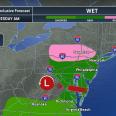
A fast-moving storm swept across the Midwest and the Appalachians on Tuesday, bringing a narrow band of mixed rain and snow along its northern edge.
The narrow corridor of mixed rain and snow shifted east-southeast Tuesday night. Some areas cooled long enough for plain snow to fall and accumulate across portions of Pennsylvania. This mix will continue into early Wednesday in portions of Pennsylvania, northern New Jersey, southeastern New York and perhaps southwestern Connecticut before temperatures rise and precipitation moves offshore.
"While the snowfall in the interstate 80, 81 and 84 corridors will be light, it will be dependent on elevation," AccuWeather Senior Meteorologist Dave Dombek said. "If it snows hard enough over the ridges and plateaus in this zone, there can be an inch or

 WJZ CBS Baltimore
 KWTX News 10
 WMTV NBC15
 The Weather Channel
 KIMT News 3
 WTOP
WTOP KSRM 920 AM
 NFL Los Angeles Rams
 People Top Story
 AlterNet
 CNN Video