
 Yahoo Canada
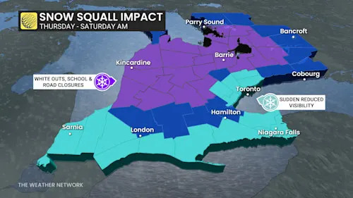
Challenging travel conditions are expected to develop Thursday afternoon and evening as lake-effect snow bands expand beyond the snowbelt regions, reaching parts of the Greater Toronto Area (GTA).
Snow totals in the GTA will remain lower; however, localized bursts of snow, combined with strong winds and dropping temperatures, will coincide with the afternoon and evening commute. Visibility could shift rapidly from clear to poor over short distances. Untreated roads may become icy and snow-covered, especially west and northwest of the GTA.
DON'T MISS: NEW COLOUR-CODED CANADIAN WEATHER ALERTS HAVE NOW LAUNCHED. HERE'S WHAT THEY MEAN IF YOU SEE THEM
In snowbelt regions, whiteouts are expected, potentially leading to road closures west of Lake Huron into Thursday night and Friday. Snowfall

 CBC News
 AlterNet
 Billboard
 Edmonton Sun World
 The Conversation
 Press of Alantic City Business
 People Crime
 People Human Interest