
 Yahoo Canada
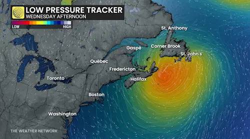
A strong low pressure system over the Atlantic is drawing Arctic air from the north and moisture from the Gulf, bringing heavy rain, strong winds, and significant snow through Wednesday. Some of the hardest-hit areas could see 30+ CM of snowfall and dangerous blizzard conditions.
Expect challenging travel with snow-covered roads and walkways. Utility outages and disruptions to transit and ferry schedules are also possible. Subsequent rain and snowmelt could lead to water pooling on roads and localized flooding in low-lying areas.
Widespread warnings are in effect.
DON'T MISS: NEW COLOUR-CODED CANADIAN WEATHER ALERTS HAVE NOW LAUNCHED. HERE'S WHAT THEY MEAN IF YOU SEE THEM
RAIN, HEAVY SNOW, AND STRONG WINDS SET TO IMPACT THE MARITIMES
Forecasters say the conditions necessary for a shar

 Real Simple Home
 The Conversation
 DoYouRemember?
 Raw Story