
 WESH 2 News
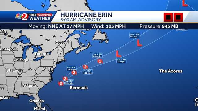
Hurricane Erin is beginning to pull away from the North Carolina coast on Thursday morning.
Erin is a Category 2 storm with maximum sustained winds of 105 mph. Latest Forecast
° F FEELS LIKE
HOURLY
DAILY RADAR TRAFFIC
As of 5 a.m., Erin was located about 185 miles southeast of Cape Hatteras, North Carolina, with an estimated minimum central pressure of 942 millibars.
The hurricane is moving north-northwest at about 17 mph.
A turn toward the north-northeast is expected on Thursday, followed by a faster motion toward the northeast and east-northeast.
Erin is forecast to remain at this intensity through Friday morning before weakening to a Category 1 storm as it moves into the northern Atlantic.
On the forecast track, the center of Erin will move over the western Atlantic b

 WFTV Channel 9
 The Newport Daily News
 CBS Philly
 Washington Examiner
  PBS NewsHour
 Salon
Salon NBC News Video
 The Daily Beast