
 1011 Now Lincoln
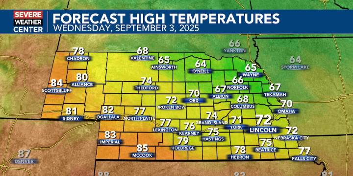
LINCOLN, Neb. (KOLN) - It is officially the 4th wettest start to September through the first two days in Lincoln’s history. More rain is possible Wednesday, but thankfully not as much as this past weekend.
Let’s take a look at skycast. Morning and afternoon showers and storms are possible Wednesday, with total amounts less than 0.25″ overall.
This is all due to a cold front moving through the area earlier in the day. As a result, highs drop back into the mid 60s to low 80s. We could also see some Canadian wildfire smoke make its way to the ground later on, so if you are sensitive to those changes, limit your time outdoors.
Milder air returns on Thursday in the form of mid 70s to upper 80s.
Another cold front will drop us back into the 60s on Friday, with 70s for the rest of the forecas

 KETK
KETK News Channel 36
 LEX 18 News
 KSNB Local4 Central Nebraska
 WOWT
WOWT KLKN-TV Lancaster County
 KMOV Sports
 FOX News Videos
 PennLive Pa. Politics
 Axios
Axios Lexology