
 USA TODAY National
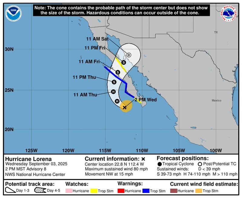
Two hurricanes are currently spinning in the Pacific Ocean, with Hurricane Lorena poised to cause life-threatening flooding in parts of Mexico and contribute to heavy rain across parts of the Southwest, including areas from southeastern California eastward to Texas.
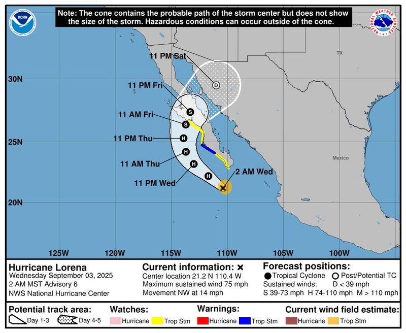
Lorena was about 190 miles west of Cabo San Lucas, and 125 miles south-southwest of Cabo San Lazaro, Mexico, at 8 p.m. ET on Sept. 3, the National Hurricane Center said. A U.S. Air Force Reserve Hurricane Hunter investigated the flight earlier in the afternoon and reported Lorena was still a hurricane, with peak maximum sustained winds of 80 mph.
Continued strengthening is forecast through the night of Sept. 3, with sustained winds peaking at 90 mph before Lorena encounters more unfavorable conditions and begins to rapidly weaken, hurricane forecasters said.
On the current forecast track, the center of Lorena is expected to move northwest, parallel to the west coast of the Baja California Peninsula through Sept. 4, before crossing over it on Sept. 5, then dissipating by Sept. 6 over the Sonoran region of Mexico. But some forecast models call for Lorena to remain over open water in the Pacific without making landfall if it weakens rapidly, the hurricane center said.
Regardless of its track, heavy rainfall, storm surge, and coastal flooding are possible along the Baja Peninsula.
The Mexican government has issued a tropical storm warning for the west coast of Baja California Sur from Santa Fe to Punta Eugenia. A tropical storm watch is in effect for the west coast of Baja California Sur from Todos Santos northward to Santa Fe, and also for the east coast of the Baja California peninsula from Santa Rosalia to Bahia de los Angeles. A warning means tropical storm conditions are expected somewhere within the area within 36 hours, while a watch means conditions are possible in the area.
US Southwest expected to see rain
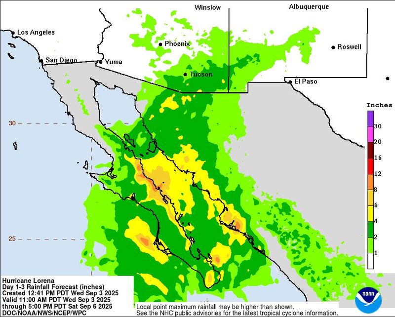
Moisture from Lorena is likely to contribute to heavy rainfall concerns across Arizona and southern New Mexico through Sept. 6, the hurricane center warned. Isolated to scattered flash flooding is possible across Arizona.
In the United States, the National Weather Service has issued flood watches for Sept. 3 to Sept. 4 for parts of southeastern California and southern Arizona.
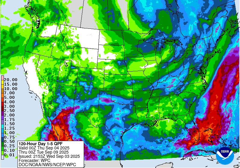
Hurricane Lorena's northward path is pushing moisture forward, and in concert with other atmospheric patterns, creating "a favorable environment for heavy rainfall" across the greater Arizona, Nevada, New Mexico border region, the Weather Prediction Center in College Park, Maryland, warned on Sept. 3. Rain storms proliferating in an area of higher terrain in the region, including the Mogollon Rim and the Grand Canyon, could produce rainfall rates of up to 2 inches an hour on Sept. 4, the prediction center said.
Lorena's ultimate impacts on the Southwest depend in part on its track, which remains uncertain, said Scott Kleebauer, a meteorologist at the center. "It's all about timing," Kleebauer said.
Arizona and New Mexico can expect to receive "a decent enhancement of moisture," Kleebauer said. "Depending on the forward speed of Lorena, it might end up pushing some of the moisture ahead quicker."
"Texas is kind of a question mark, but it does look like at least some of the moisture will make it into that area," he added, likely focused primarily along and to the south of Interstate 20. The weather service also will be monitoring a frontal boundary approaching from the north to see how that will interact with Lorena's moisture over the weekend and into early next week, he said.
Parts of Mexico to see flooding rain, storm surge
Heavy rainfall and life-threatening flash flooding have already begun to occur over Baja California in Mexico on Wednesday, Sept. 3, and are expected to keep expanding northward, the hurricane center said. Bands of heavy rainfall are expected to move into southeastern Baja California and southwestern Sonora by Thursday, Sept. 4, the hurricane center said, with the rainfall potentially persisting until Friday.
Rainfall totals of 5 to 10 inches, with maximum amounts of 15 minutes, are possible in Mexico, along the coast and Gulf of California shores through Friday, bringing the risk of life-threatening flash floods and mudslides, especially in areas of higher terrain.
Additionally, 1 to 3 inches of rain, with localized totals up to 4 inches, is forecast from the northwest Mexican states of Sinaloa and Sonora northward into Arizona through Friday, Sept. 5, bringing the potential for isolated to scattered flash flooding.
The other hurricane, Hurricane Kiko, has maximum sustained winds of 130 mph with higher gusts, a Category 4 hurricane on the Saffir-Simpson Hurricane Wind Scale. Kiko was about 1,600 miles east of Hilo, Hawaii, on the evening of Sept. 3, moving west at 9 mph, the hurricane center said.
Kiko was still undergoing strengthening and could reach winds of 145 mph on Sept. 4, according to the center's forecast, which indicates Kiko is likely to remain a hurricane through at least Sept. 8.
Storm tracker: Tracking path of Hurricane Lorena
This forecast track shows the most likely path of the center of the storm. It does not illustrate the full width of the storm or its impacts, and the center of the storm is likely to travel outside the cone up to 33% of the time.
Hurricane Lorena spaghetti models
Illustrations include an array of forecast tools and models, and not all are created equal. The hurricane center uses only the top four or five highest-performing models to help make its forecasts.
Hurricane center also tracking a tropical wave in the Atlantic
Meanwhile, in the Atlantic, the hurricane center is keeping tabs on a tropical wave located over the eastern tropical Atlantic, a few hundred miles west-southwest of the Cabo Verde islands.
Forecasters said the wave continues to produce disorganized showers and thunderstorms, and that environmental conditions are conducive for gradual development of this system during the next several days. A tropical depression is likely to form late this week or this weekend, forecasters said in a Sept. 3 advisory.
The system is expected to move westward to west-northwestward around 15 mph across the eastern and central tropical Atlantic into early next week, with forecasters giving the system an 80% chance of formation through the next seven days.
Gabe Hauari is a national trending news reporter at USA TODAY. You can follow him on X @GabeHauari or email him at Gdhauari@gannett.com.
This article originally appeared on USA TODAY: Hurricane Lorena could bring rain to US Southwest: See path tracker
Reporting by Gabe Hauari and Dinah Voyles Pulver, USA TODAY / USA TODAY
USA TODAY Network via Reuters Connect

 Mediaite
 Insider