
After weeks of bone-dry weather, we're finally seeing signs of life with Thursday turning active. Morning showers and thunderstorms will impact the commute with additional rounds developing late in the morning before slowly sliding into southeastern counties later in the day. Watch for gusty wind and locally heavy rain, there is a slim chance for isolated strong to severe storms southeast (damaging wind) in the afternoon. Rainfall will range from a few tenths of and inch up to 1" to 2" on the high end. Not a drought breaker but certainly beneficial. With rain and extensive cloud cover, highs will stay well below normal, in the mid to upper 70s. Expect a quick warm up into the mid to upper 80s with sunshine to start the weekend. Another round of showers and strong storms is likely Friday ni
Rounds of Showers and Storms Thursday
 LEX 18 News9 hrs ago
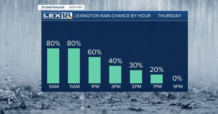
95

 WRCB-TV
 WJHL
WJHL WYFF News 4
 El Paso Times
 NewsTalk 1280
 Shelby Star
 CBS Los Angeles
 Arizona's Family
 KOLO8
KOLO8 Florida Today
 Tucson News Now
 Mediaite