
 USA TODAY National
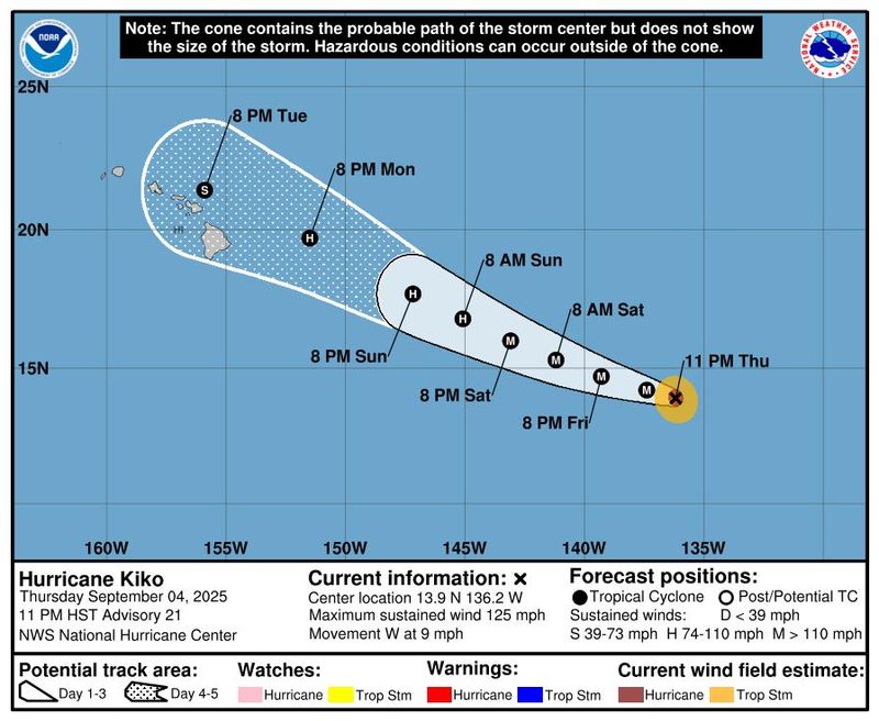
Hurricane Kiko, which was spinning as a Category 3 storm in the Pacific Ocean on Sept. 5, continued churning toward the Hawaiian Islands and will begin creating dangerous surf conditions by the end of the weekend before its arrival.
Hurricane forecasters said Kiko could pass near Hawaii or possibly make landfall sometime toward the middle of next week, but it's still too soon to tell its exact trajectory or what impacts it could have. Even if the storm doesn't make landfall, "the risk of direct impacts from wind and rainfall is increasing," the National Hurricane Center said.
As of 11 a.m. Sept. 5 EDT, Kiko was 1,245 miles east-southeast of Hilo, on the Island of Hawaii, also called the Big Island.
Its sustained winds were about 115 mph with higher gusts, making it a Category 3 storm on the Saffir-Simpson Hurricane Wind Scale. It was weakening from an earlier peak of 145 mph, when it reached Category 4 strength on Sept. 4.
Hurricane Kiko was moving west-northwest on Sept. 5 and is expected to continue on that path for the next several days. It could also strengthen in the next day before slowly weakening over the weekend.
Will Hurricane Kiko hit Hawaii?
There is still too much uncertainty with forecast models to tell if Kiko will make landfall, forecasters said.
The National Hurricane Center's forecast currently has Kiko passing just to the north of the Big Island as a tropical storm on Sept. 9.
"Statewide, flash flooding is a possibility," the National Weather Service in Honolulu said. "At a minimum, increased showers are expected through much of next week."
In addition, the hurricane center warned that "swells generated by Hurricane Kiko could begin reaching the Hawaiian Islands towards the end of this weekend. These swells could cause life-threatening surf and rip currents."
If Kiko made a direct hit either as a hurricane or tropical storm, it would be a rare landfall for the Hawaiian Islands, which have seen just two hurricanes and seven tropical storms make landfall since 1950, according to the National Oceanic and Atmospheric Administration's historical hurricane path tracker. Others have passed near the islands.
Former Hurricane Lorena brings heavy rainfall
Elsewhere in the Pacific, the remnants of what had been Hurricane Lorena were stalled about 170 miles off the coast of Baja California Sur as a remnant low-pressure area, driving heavy rainfall and a risk of life-threatening flash flooding. A total of 12 inches of rain from the system is possible in Baja California Sur and Sonora, Mexico, the hurricane center said.
Through the start of the weekend, Lorena was also impacting the U.S. Southwest, with 1 to 3 inches of rain and 4 inches locally expected in parts of Arizona and New Mexico, with chances for flash flooding.
See the storms in the Pacific Ocean
How do hurricanes form?
Hurricanes are born in the tropics, above warm water. Clusters of thunderstorms can develop over the ocean when water temperatures exceed 80 degrees Fahrenheit. If conditions are right, the clusters swirl into a storm known as a tropical wave or tropical depression.
A tropical depression becomes a named tropical storm once its sustained wind speeds reaches 39 miles per hour. When its winds reach 74 mph, the storm officially becomes a hurricane.
Prepare now for hurricanes
Delaying potentially lifesaving preparations could mean waiting until it’s too late. "Get your disaster supplies while the shelves are still stocked, and get that insurance checkup early, as flood insurance requires a 30-day waiting period," the National Oceanic and Atmospheric Administration recommends.
- Develop an evacuation plan. If you are at risk from hurricanes, you need an evacuation plan. Now is the time to begin planning where you would go and how you would get there.
- Assemble disaster supplies. Whether you’re evacuating or sheltering in place, you’re going to need supplies not just to get through the storm but for a possibly lengthy aftermath, NOAA said.
- Get an insurance checkup and document your possessions. Contact your insurance company or agent now and ask for an insurance checkup to make sure you have enough insurance to repair or even replace your home and belongings. Remember, home and renters insurance don’t cover flooding, so you’ll need a separate policy for those. Flood insurance is available through your company, agent or the National Flood Insurance Program. Act now, because flood insurance requires a 30-day waiting period.
- Create a family communication plan. NOAA says you should take the time now to write down a hurricane plan and share it with your family. Determine family meeting places and make sure to include an out-of-town location in case of evacuation.
- Strengthen your home. Now is the time to improve your home’s ability to withstand hurricanes. Trim trees and install storm shutters, accordion shutters and impact glass; seal outside wall openings.
This article originally appeared on USA TODAY: Will Hurricane Kiko hit Hawaii? Latest forecast for Category 3 storm in Pacific
Reporting by Jeanine Santucci and Doyle Rice, USA TODAY / USA TODAY
USA TODAY Network via Reuters Connect

 America News
 New York Post
 Independent Record
 The Register-Guard
 People Human Interest
 WENY News
 Reuters US Top
 AccuWeather Severe Weather
 Associated Press US and World News Video
 NBC 5 Dallas-Fort Worth Entertainment