
 USA TODAY National
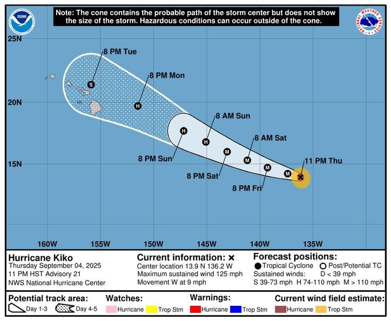
Hurricane Kiko continues to barrel toward the Hawaiian Islands as a major hurricane and is expected to begin creating dangerous surf conditions in the coming days.
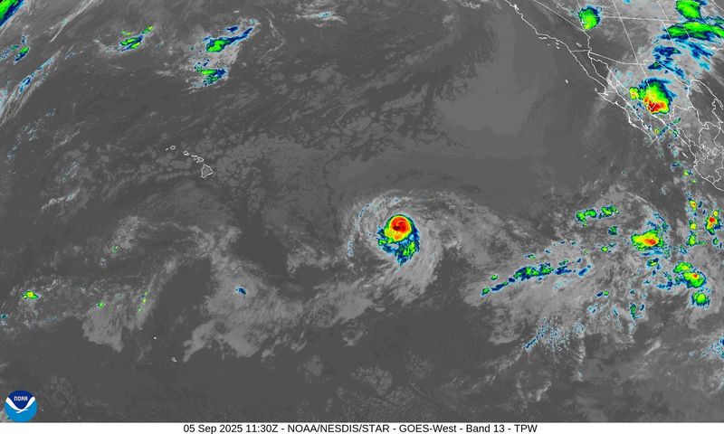
According to a late-night advisory from the National Hurricane Center on Thursday, Sept. 4, Kiko is located about 1,515 miles east-southeast of Honolulu with maximum sustained winds near 125 mph with higher gusts, making it a Category 3 hurricane on the Saffir-Simpson Hurricane Wind Scale.
Hurricane center forecasters said some strengthening is possible throughout the day on Friday, Sept. 5, followed by slow weakening beginning Friday night and through the weekend.
Hurricane forecasters said Kiko could pass near Hawaii or possibly make landfall sometime toward the middle of next week, but it's still too soon to tell its exact trajectory or what impacts it could have. Even if the storm doesn't make landfall, "the risk of direct impacts from wind and rainfall is increasing," the National Hurricane Center said.
Forecasters said Kiko is moving westward around 9 mph, with a gradual turn toward the west-northwest expected Friday, Sept. 5, with this motion forecast to continue through the weekend with a slight increase in forward speed.
The NHC said swells generated by Kiko could begin reached the Hawaiian Islands toward the end of this weekend, causing life-threatening surf and rip current conditions.
Storm tracker: Tracking path of Hurricane Kiko
This forecast track shows the most likely path of the center of the storm. It does not illustrate the full width of the storm or its impacts, and the center of the storm is likely to travel outside the cone up to 33% of the time.
Hurricane Kiko spaghetti models
Illustrations include an array of forecast tools and models, and not all are created equal. The hurricane center uses only the top four or five highest-performing models to help make its forecasts.
NHC continues to track tropical wave in the Atlantic
In the Atlantic, the hurricane center said it is tracking a broad area of low pressure over the eastern tropical Atlantic that is producing a disorganized area of showers and thunderstorms.
Environmental conditions are favorable for development of this system, currently labeled as Invest 91L, and a tropical depression is likely to form over the weekend or early next week as the system moves slowly westward across the central tropical Atlantic.
Forecasters said this system is likely to be near the Lesser Antilles by the middle to latter part of next week, and interests there should monitor its progress. The hurricane center gives the system a 90% chance of formation through the next seven days.
How do hurricanes form?
Hurricanes are born in the tropics, above warm water. Clusters of thunderstorms can develop over the ocean when water temperatures exceed 80 degrees. If conditions are right, the clusters swirl into a storm known as a tropical wave or tropical depression.
A tropical depression becomes a named tropical storm once its sustained wind speeds reach 39 mph. When its winds reach 74 mph, the storm officially becomes a hurricane.
Prepare now for hurricanes
Delaying potentially lifesaving preparations could mean waiting until it’s too late. "Get your disaster supplies while the shelves are still stocked, and get that insurance checkup early, as flood insurance requires a 30-day waiting period," the National Oceanic and Atmospheric Administration recommends.
- Develop an evacuation plan. If you are at risk from hurricanes, you need an evacuation plan. Now is the time to begin planning where you would go and how you would get there.
- Assemble disaster supplies. Whether you’re evacuating or sheltering in place, you’re going to need supplies not just to get through the storm but for a possibly lengthy aftermath, NOAA said.
- Get an insurance checkup and document your possessions. Contact your insurance company or agent now and ask for an insurance checkup to make sure you have enough insurance to repair or even replace your home and belongings. Remember, home and renters insurance don’t cover flooding, so you’ll need a separate policy for those. Flood insurance is available through your company, agent or the National Flood Insurance Program. Act now, because flood insurance requires a 30-day waiting period.
- Create a family communication plan. NOAA says you should take the time now to write down a hurricane plan and share it with your family. Determine family meeting places and make sure to include an out-of-town location in case of evacuation.
- Strengthen your home. Now is the time to improve your home’s ability to withstand hurricanes. Trim trees and install storm shutters, accordion shutters and impact glass; seal outside wall openings.
Gabe Hauari is a national trending news reporter at USA TODAY. You can follow him on X @GabeHauari or email him at Gdhauari@gannett.com.
This article originally appeared on USA TODAY: Hurricane Kiko path tracker, spaghetti models: See where the storm is headed
Reporting by Gabe Hauari and Jeanine Santucci, USA TODAY / USA TODAY
USA TODAY Network via Reuters Connect

 FOX Weather
 New York Daily News Snyde
 IMDb TV
 The Hill Politics
 5 On Your Side Sports
 The Babylon Bee