
 USA TODAY National
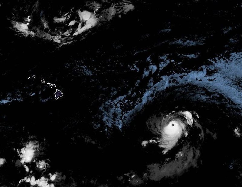
The National Hurricane Center is tracking systems in both the Atlantic and Pacific oceans on Saturday, Sept. 6.
Hurricane Kiko is holding its own in the Central Pacific Ocean, but a tropical wave moving westward across the Atlantic Ocean continues to look less and less impressive.
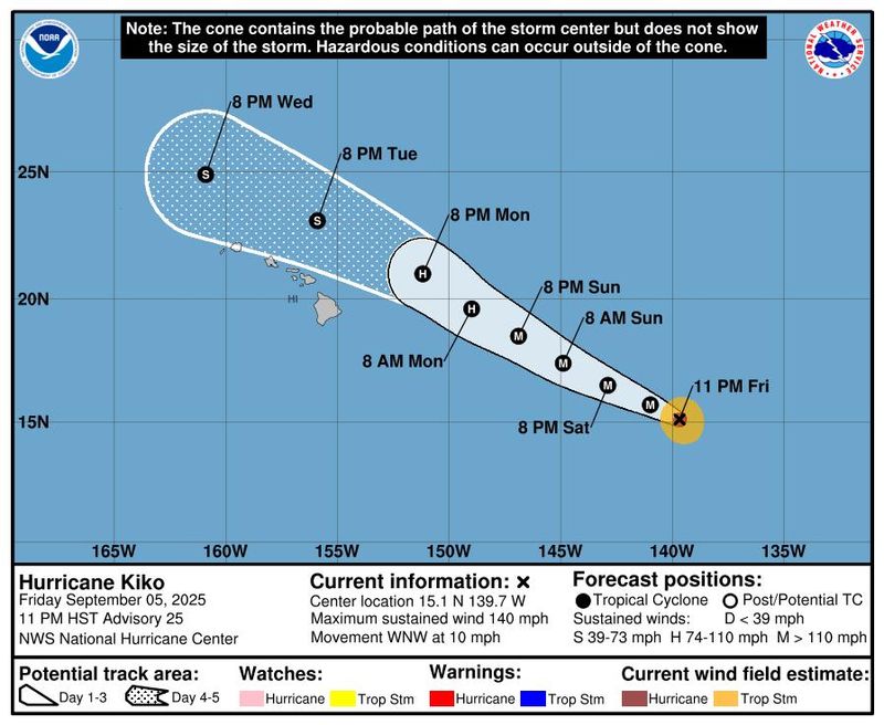
Hurricane Kiko – maintaining sustained winds of 140-mph – is expected to begin weakening over the weekend but could still retain hurricane strength on Sept. 8 as it approaches waters to the north of the Hawaiian Islands, the National Hurricane Center said.
The state of Hawaii issued an emergency declaration on Sept. 5, an administrative action government agencies often take before tropical storms, hurricanes and other impending weather disasters. Such declarations pave the way for emergency measures and resources that allow officials to respond quickly during emergencies.
The declaration was signed by Acting Governor Sylvia Luke, the state's lieutenant governor, because Governor Josh Green is traveling on official business and plans to return to the state on Sept. 7, according to a state news release. State Attorney General Anne Lopez is scheduled to serve as acting governor on Sept. 6 and 7.
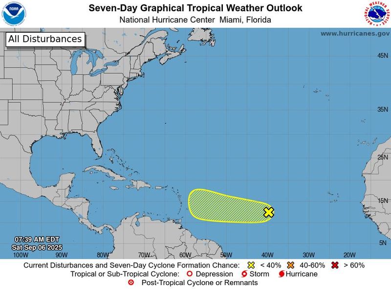
In the Atlantic, still more than a thousand miles east of the Caribbean, a tropical wave that had been forecast to produce a tropical depression or tropical storm is only producing a small, disorganized area of storms, the hurricane center said on Saturday, Sept. 6. The center now shows only a 30% chance of further development along the wave over the next seven days.
Hurricane Kiko approaching Hawaii
Hurricane Kiko was centered about 1,065 miles east-southeast of Hilo and about 1,265 miles east-southeast of Honolulu, at 8 a.m. EDT on Saturday and was and moving west-northwestward at about 10 mph. The hurricane is forecast to finally weaken to tropical storm force winds by Sept. 9 as it passes to the north of the islands.
As Kiko approaches the islands during the early-to-middle portion of the weekend, rain and wind remain a possibility, but the hurricane center and the National Weather Service say it’s too soon to determine the exact location or magnitude of impacts. The latest advisories remind people in the islands to monitor the storm’s progress.
Portions of Kauai and Oahu remain in the potential path of the center of the hurricane, the NHC's forecast graphic showed, but the listed probabilities of tropical storm force winds are very low across the islands, and no probabilities at all are listed for hurricane-force winds.
Swells from the far away hurricane are forecast to begin reaching the Big Island and Maui over the weekend and will continue to build and increase along east-facing shorelines through the middle of the week. The swells could produce life-threatening surf and rip currents, the National Weather Service said.
Meanwhile, in an area of the Eastern Pacific that has been particularly productive this summer, forecasters are watching a new low pressure area a few hundred miles off Mexico’s southwestern coast. The area shows only a low chance of further development over the next seven days.
Track active storms
This forecast cone from the National Hurricane Center shows only the probable path of the center of a storm. It does not illustrate the full range of impacts possible from a storm such as swells, rain and winds.
Dinah Voyles Pulver, a national correspondent for USA TODAY, has written about hurricanes, tornadoes and violent weather for more than 30 years. Reach her at dpulver@usatoday.com or @dinahvp on Bluesky or X or dinahvp.77 on Signal.
This article originally appeared on USA TODAY: Hurricane Kiko forecast prompts emergency declaration in Hawaii
Reporting by Dinah Voyles Pulver, USA TODAY / USA TODAY
USA TODAY Network via Reuters Connect

 13 On Your Side
 CBS Sacramento CBS13
 The radio station 99.5 The Apple
 Hawaii News Now
 Reuters US Top
 New York Post
 FOX News Videos