
 WKOW 27
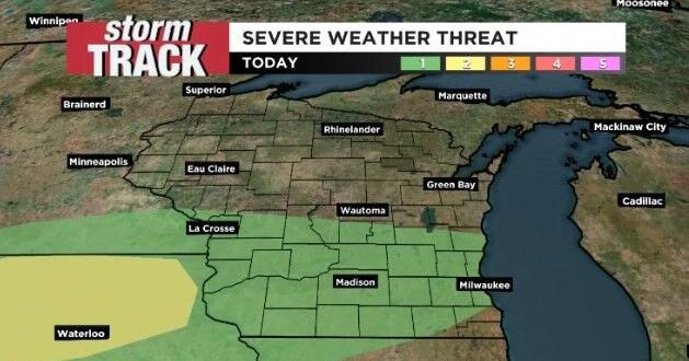
Download the 27 StormTrack Weather app to receive mobile weather alerts
A cold front moving through southern Wisconsin forcing that warmer air, from the warm front this morning, to rise and lead to the development of showers and storms. We are under a level 1 out of 5 risk of severe weather meaning we have a chance for stronger storms continuing this evening. While widespread severe weather is not expected, isolated strong winds or small hail will be possible. The best chance for this will be for the areas that get the most sun before storms move in, as the warming associated with this provides energy for storms.
Overnight we could see a few more showers and storms, but for tomorrow morning we look to stay dry with maybe a stray shower here and there. We will stay on the cooler side with

 Associated Press US and World News Video
 CBS DFW
 Times Herald
 Ocala Star-Banner
 KSNB Local4 Central Nebraska
 The Tennessean
 Democrat and Chronicle
 Hawaii News Now
 NBC News