
 FOX 13 Tampa Bay Crime
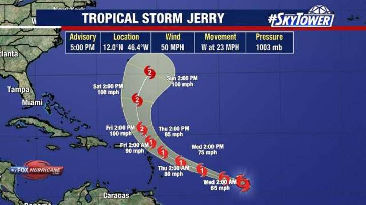
TAMPA, Fla. - Tropical Storm Jerry formed on Tuesday morning in the Central Atlantic and will likely strengthen into a hurricane this week.
As of 5 p.m., it was located at 12.0°N 46.4°W., which is about 1,315 miles to the east-southeast of the northern Leeward Islands and is moving off to the west at 23 mph and had maximum sustained winds of 50 miles per hour.
What's next:
Tropical Storm Jerry is expected to pass near just north of the northern Leeward Islands on Thursday night and early Friday morning.
Watches may be issued for a portion of the area on Tuesday afternoon or evening because there is an increased risk of wind, surf and rainfall.
The NHC said a decrease in forward speed and a turn to the west-northwest is expected over the next few days.
Many of the computer models

 Wilmington Star-News
 10 Tampa Bay
 KONP
KONP News Collection
 Page Six
 LiveNOW from FOX Crime
 America News
 5 On Your Side Sports
 ABC 7 Chicago Health
 Glam
Glam Breitbart News