
 USA TODAY National
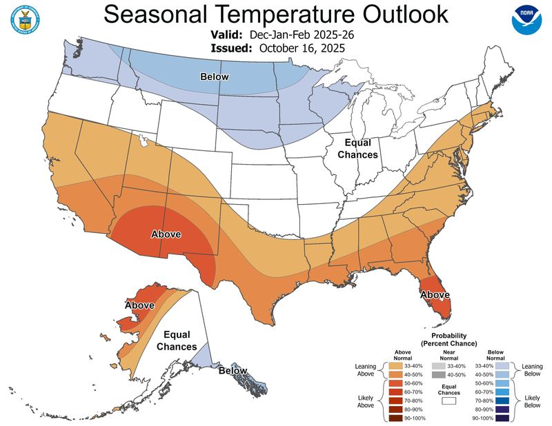
Winter is coming − but how cold is it going to be? Federal forecasters from NOAA's Climate Prediction Center gave us their answer Oct. 16 in their annual winter outlook.
According to the forecast, a warmer-than-average winter is most likely across the southern tier of the nation, as well as in California and along much of the East Coast and Florida. Colder-than-normal conditions are expected in the Pacific Northwest and across the upper Midwest.
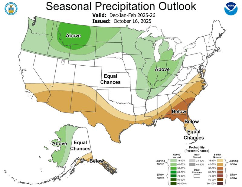
As for snow and rain, the northern Rockies and Great Lakes region are most likely to see plenty of precipitation this winter, the Climate Prediction Center said. However, a drier-than-average winter is expected along the nation's southern tier, especially in the Southeast.
The center's forecast covers the months of December, January and February, which is known as meteorological winter.
Where will it be colder-than-normal in winter 2025-2026?
According to Jon Gottschalck, chief of the operational prediction branch of the Climate Prediction Center, "colder than normal conditions are most likely for a region from parts of the Pacific Northwest, eastward to include the northern Rockies, northern Plains and upper Mississippi Valley."
He added that extreme southeastern mainland Alaska and the Alaska Panhandle also are favored to see below-normal temperatures this coming winter.
Where will it be warmer-than-normal in winter 2025-2026?
Gottschalck said that warmer-than-normal temperatures are most likely for California, the southern Great Basin, the southern Rockies, the Southwest eastward to Texas, the Southeast and the coastal mid-Atlantic.
Above-normal temperatures are also favored for much of the northern and western coasts of Alaska. The greatest confidence in warmer conditions is in the Southwest, southern Florida and northwest Alaska, he said.
Snow forecast unclear, but NOAA predicts precipitation
The forecast released Oct. 16 predicts only where above- or below-normal temperatures and above- or below-normal precipitation are most likely.
This winter forecast does not specify how much precipitation will fall as rain, snow or ice, only that more or less is likely overall. Snow forecasts depend upon the strength and track of winter storms, which generally cannot be predicted more than a week in advance, the center has said.
Wondering how much snow has fallen near you? USA TODAY's detailed map lets you explore snowfall accumulation over the past 24, 48, and 72 hours. You can also check seasonal totals starting from Oct. 1.
Given La Niña conditions, which favor below-normal precipitation in the Southwest U.S., drought is most likely to persist or further degrade in some areas.
However, with the enhanced likelihood of wetter-than-normal conditions in the Pacific Northwest and northern Rockies over the winter season, improvement in drought conditions is favored in these areas.
"An important point to add is that drought development is forecast for the southern Plains, areas in the Southeast and lower mid-Atlantic," Gottschalck said.
What are likely to be the main drivers of weather across the country this winter?
The primary driver is the return of La Niña conditions, Gottschalck said. Even though it is considered a weak event, likely shorter than normal in duration, its impact is likely to be strongest during the winter season and so plays a large role in the outlooks.
Another factor includes the warm blob of Pacific Ocean water that's currently sitting off the West Coast. He said "there could be a potential influence from the large area of north Pacific ocean sea-surface temperatures, which at the current time are considerably above average." However, he said that these temperatures "can change and vary very quickly due to changes in storm track so any predictive influence is highly uncertain, but it was considered."
What about the polar vortex?
"Explicit predictability of the strength of the stratospheric polar vortex is limited unfortunately to about 2-3 weeks in advance," Gottschalck said. "So we cannot make specific, highly reliable forecasts of its strength this far in advance."
However, he added that the conditions anticipated this winter do "slightly tilt the odds for a weaker polar vortex at times this winter season." A weaker polar vortex ups the odds for Arctic air outbreaks across the nation, he said.
Other patterns aren't figured in
Climate patterns such as the Arctic Oscillation – which can unleash intensely cold temperatures across the central and eastern U.S. – aren't included in this official forecast at this time because they can't be predicted more than one or two weeks in advance.
Other large-scale climate patterns in the atmosphere that can influence winter weather include the Madden-Julian Oscillation, which can affect the number of heavy-rain events along the West Coast. It also can contribute to other extreme events in the United States, including arctic air outbreaks during the winter months across the central and eastern portions of the nation, the Climate Prediction Center said.
The forecast also does not factor in Siberian snow cover, which other forecasters use as the basis for their winter weather forecasts.
What do other winter forecasts say?
AccuWeather also released its winter forecast earlier in October, and the private forecaster said that a "bookend winter" is on tap for the central and eastern U.S., with the biggest storms expected around the opening and the final weeks of the season. "It can be an intense stormy winter for areas of the country, particularly across the Midwest, Great Lakes, Ohio Valley, Northeast and parts of the mid-Atlantic," AccuWeather lead long-range meteorologist Paul Pastelok said.
Elsewhere, AccuWeather says that a warm, dry pattern will be most pronounced across California and the Southwest, where worsening drought and the risk of out-of-season wildfires are expected.
This article originally appeared on USA TODAY: How cold, snowy will winter be? New NOAA forecast holds clues.
Reporting by Doyle Rice, USA TODAY / USA TODAY
USA TODAY Network via Reuters Connect

 WEVV 44News
 KRIS 6 News Weather
 FOX Weather
 NBC 5 Dallas-Fort Worth Sports
 CNN
CNN Raw Story
 The Conversation
 Essentiallysports College Sports
 The Daily Bonnet
 Essentiallysports Motorsports