
 WSIL-TV
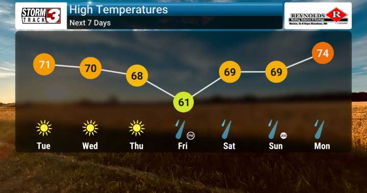
It looks like we're in for a bit of a breezy and cooler-than-normal pattern as we move through the remainder of our week across the region. We're keeping a close eye on the atmosphere as a significant weather system develops upstream. A strong upper-level system will dig across our area tomorrow (Tuesday), bringing with it cooler air and breezy conditions.
We can expect winds to be quite active, especially this afternoon and into Tuesday, with gusts potentially ranging from 25 to 35 mph.
Looking ahead, the column of air remains quite dry for Wednesday, but we'll see a gradual shift towards the end of the week. High pressure will build in from the south, bringing a potential for increased moisture and that means a much greater chance for rain showers starting Friday and continuing through

 KBTX News 3
 NewsTalk 1280
 PennLive Pa. Politics
 FOX 13 Tampa Bay Crime
 Denver7 News
 Associated Press Top News
 KNOE
KNOE FOX 32 Chicago
 KTVU Channel 2
 CBS19 News Crime
 The Hill