
 WBRC
WBRC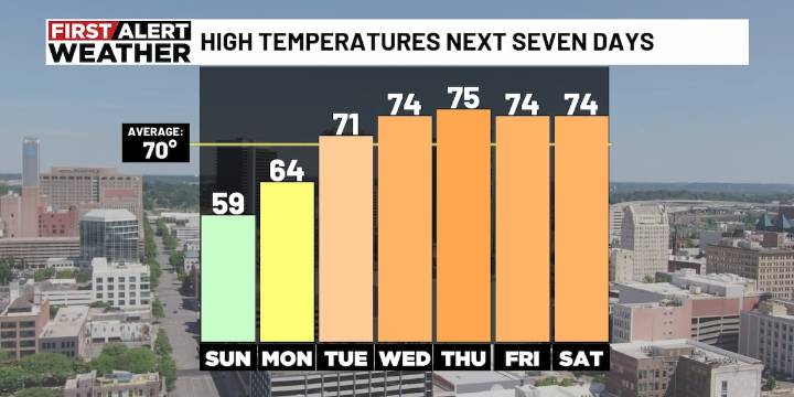
BIRMINGHAM, Ala. ( WBRC ) - We’re giving you a First Alert for a cold start to Monday. Temperatures will dip into the mid to upper 30s before sunrise. If you have any sensitive plants, you may want to cover them up or bring them inside Sunday night.
A Frost Advisory is in effect for much of the area. The coldest readings will likely be in Marion, Winston, Fayette, Walker, Cullman, Blount, Etowah, and Cherokee counties — those areas tend to cool off the quickest under clear skies.
After that chilly start, Monday will turn into a beautiful day. Expect plenty of sunshine with afternoon highs warming into the mid 60s. A light north wind at 5 to 10 mph will keep the air feeling crisp. This will likely be our last day of below-average temperatures for a while.
Next Big Thing: If you’ve

 The List
 Crooks and Liars
 WFMJ-TV Politics
 Raw Story
 Newsweek Top
 The Monroe News