
 KSAT 12
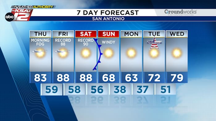
FORECAST HIGHLIGHTS • PATCHY AM FOG: Brief, morning fog will give way to sunny conditions • NEAR-RECORD HIGHS: We’ll be near 90 both Friday & Saturday • SUNDAY PLUNGE: Strong front will drop temps, very gusty winds
FORECAST
AM FOG, PM SUN TODAY
Patchy fog is forecast to develop this morning, with visibility rapidly improving by 9am. This could impact the morning commute for some, but not everyone will be affected.
Then, full, afternoon sunshine will push highs into the low to mid-80s.
NEAR-RECORD HIGHS FRIDAY & SATURDAY
Before a front moves through Saturday night, temperatures are expected to spike both Friday and Saturday afternoon. As of now, highs will be in the upper-80s, but low-90s can’t be ruled out. Record highs will be challenged.
SUNDAY PLUNGE, FIRE DANGER
A strong

 Eyewitness News 3
 Gothamist
 KSL Utah
 NECN Providence
 KSLA News
 Lansing State Journal
 AccuWeather Severe Weather
 Timeout New York
 Ocala Star-Banner
 CBS Sacramento Dixon News
 Associated Press Elections