
 WAFB
WAFB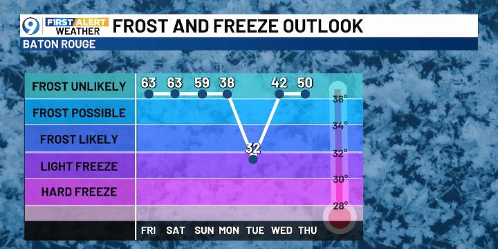
BATON ROUGE, La. (WAFB) - An Arctic cold front will move in Sunday morning...ahead of the front, we’ll have warmer conditions, followed by a sharp cool-down next week.
DENSE FOG ADVISORY
Thursday will begin with areas of dense fog and a dense fog advisory in effect through 9AM for reduced visibility. Use caution on the roads.
THURSDAY’S WEATHER
The forecast will start with areas of dense fog through 9AM, followed by a mix of sun and clouds and warm conditions. Afternoon highs will be near 80 degrees. We’ll see above-normal highs through Saturday.
TIMING THE COLD FRONT AND ANY RAIN
There won’t be much in the way of rain/storms with this strong cold front, which will arrive on our doorstep early Sunday morning. This will yield a big change in the temperature department, with the coolin

 WDSU New Orleans
 KSLA News
 Nola Entertainment
 Vogue Fashion
 AlterNet
 Raw Story
 Esquire
 SpoilerTV
 RadarOnline
 Fox 11 Los Angeles Sports