
 USA TODAY National
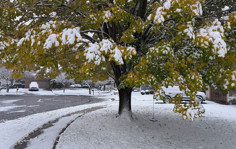
Heavy snow flew across the Great Lakes region on the morning of Monday, Nov. 10 as a frigid airmass brought "sharply colder" weather across the eastern two-thirds of the country, with temperatures between 20 to 30 degrees below average expected to break many records across the Southeast through the night of Nov. 10, the National Weather Service said.
Snow was reported falling in Chicago for much of the morning. Several reports of around a foot of snow were reported around the Great Lakes in the morning, according to the National Weather Service, including 14 inches near Big Bay, Michigan; 13 inches in Kenosha County, Wisconsin; and 11.5 inches in Lakeville, Indiana.
The weather service said freeze watches and warnings were in effect from the Lower Mississippi Valley to the Virginia Tidewater through the morning of Tuesday, Nov. 11, with winter weather advisories in effect across multiple states, including portions of Ohio, Wisconsin, Virginia, Tennessee, Illinois, Indiana, and New York, among others.
Record-breaking cold was possible in Florida, forecasters said.
According to AccuWeather's latest forecast, a "significant round of snow" was likely from the shores of Lake Superior to Lake Ontario, affecting areas such as Chicago, Cleveland, Buffalo, and Pittsburgh, among others.
"This storm pattern will introduce some of the coldest air seen for early November, and that is the reason for the robust snow amounts expected in the Great Lakes and the far southern extent of the flurries into the southern Appalachians," said AccuWeather Senior Meteorologist Chad Merrill on the site's morning forecast for Monday, Nov. 10.
Where will it snow?
According to the NWS office in Chicago, "gusty lake-effect snow" is ongoing and expected to impact the morning commute on Nov. 10. Forecasters said conditions will vary "considerably" across short distances, and travel is not advised where the snow is occurring.
"Snow will gradually diminish from north to southeast through the morning," NWS said.
The NWS office in Buffalo said generally light snow on Nov. 10, will give way to "developing areas of lake effect snow southeast of the lakes," which are then forecast to shift to areas east of the lakes and weaken Tuesday, Nov. 11.
Areas near Albion and Rochester are likely to see between 4 to 6 inches of snow, while areas slightly to the east, such as Sodus and Fulton, are expected to see between 6 to 8 inches of snow.
In Cleveland, the weather service said "off and on snow showers" are expected to continue through Monday, with the bulk of the accumulations expected in the traditional snow belt area, especially inland northwestern Pennsylvania. The weather service said Erie County, Pennsylvania, could see between 6 to 11 inches of snow, with locally higher amounts possible in areas of higher elevation.
According to AccuWeather, accumulating snow will expand across southeastern Indiana, southern Ohio, central and northern Pennsylvania, and into the Appalachian Mountains, with snow showers potentially expanding southward into eastern Kentucky, southern West Virginia, eastern Tennessee, and portions of the Carolinas early this week.
Florida freeze
On the night of Monday, Nov. 10, very low overnight temperatures will continue to creep southward through areas of the Mississippi Valley and Southeast states, AccuWeather said.
Even portions of the Florida Panhandle and coastlines are projected to observe low temperatures in the 30s and 40s.
According to the National Weather Service, record breaking cold temperatures are also possible for much of the Florida peninsula on Tuesday, Nov. 11, as the polar airmass continues its southward progression.
"The Florida Peninsula will shiver, with highs stuck in the 50s as far south as Central Florida, and 60s will be as warm as it gets in South Florida, all likely to set daily records for cold high temperatures," said Weather.com meteorologist Jonathan Erdman in an online forecast.
How long will the cold snap last?
"If this cold is too soon for you, we have some good news: It won't last that long," Erdman said.
He said milder air will already return to the nation's mid-section by Tuesday, Nov. 11. "And that milder air will spread through much of the South, then Midwest the rest of this week."
However, the chilly air may be somewhat more stubborn to leave the Northeast, as another reinforcing cold front sweeps out of Canada, according to Weather.com.
This story has been updated with new information.
Gabe Hauari is a national trending news reporter at USA TODAY. You can follow him on X @GabeHauari or email him at Gdhauari@gannett.com.
This article originally appeared on USA TODAY: Heavy snow wallops North as Southerners shiver in record cold.
Reporting by Gabe Hauari and Doyle Rice, USA TODAY / USA TODAY
USA TODAY Network via Reuters Connect

 WFMJ-TV
 Pittsburgh Post-Gazette
 Akron Beacon Journal
 Voice of Alexandria Sports
 OK Magazine
 America News
 New York Post
 ESPN NFL Headlines