
 21Alive News
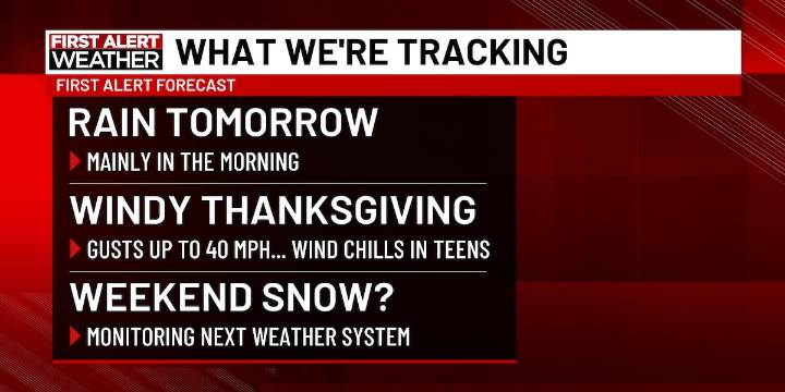
FORT WAYNE, Ind. (WPTA) - Enjoy the 50s for the start of the week because a much colder dip is coming soon... and we’re monitoring the potential for the next snow in the Midwest!
It’s a cloudy start to the workweek with highs reaching the mid 50s today. The cloud cover will hold tight for a while; any brief peeks of sunshine will be cherished in a bit more of a ‘gloomy’ week ahead! Our next round of rain arrives late tonight into tomorrow morning. We’ll deal with on-and-off rain during Tuesday morning’s commute, but this will begin to wrap up in the afternoon.
A bigger cold front rolls through midweek, kicking up winds. Wind gusts on Wednesday and Thursday will reach up to 30-40 mph. Wind chills on Thanksgiving will be down in the teens and low 20s. Despite a cold and blustery forecast,

 Daily Voice
 WCBI-TV
 Jackson Citizen Patriot
 KPLC
KPLC The Babylon Bee
 Arizona's Family
 NonStop Local
 WCNC Charlotte Weather
 WIS News 10
 Mediaite