
 The Conversation
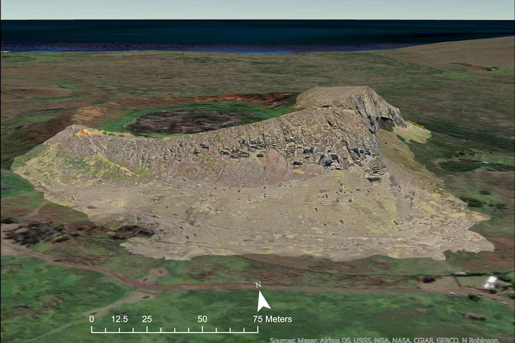
Rapa Nui, also known as Easter Island, is often portrayed in popular culture as an enigma. The rationale is clear: The tiny, remote island in the Pacific features nearly 1,000 enormous statues – the moai. The magnitude and number of these monuments defy easy explanation.
Since European ships first encountered these stone giants in the 18th century, outsiders have branded the island as fundamentally mysterious, possibly beyond archaeologists’ ability to explain. This characteristic is part of what makes the island famous. Tour operators market the inexplicable. Documentaries promise unsolved puzzles. Popular books ask how “primitive people” could possibly move 70-ton megaliths.
Archaeological researchers have put forward various explanations for the statues, which were made between 1200 and 1700, but there remains no consensus. For decades, experts offered plausible scenarios: powerful chiefs commanding workers, elite-controlled statue quarries, wooden sleds drawn by hundreds of islanders, roller systems, wooden rails and ceremonial pathway markers. Based on authoritative assertions and compelling narratives, these accounts are rarely connected to archaeological evidence.
I’m an archaeologist who has been studying Rapa Nui for more than two decades. In newly published research, my colleagues and I believe we’ve solved the mystery in three essential ways.
First, using 11,686 photographs taken by drone, we created a comprehensive, three-dimensional model of Rano Raraku, the volcanic crater where 95% of Rapa Nui’s moai were carved. It was a systematic documentation – every slope, every carved surface, every production feature captured at a resolution down to the centimeter. The model generated predictions that we and other researchers could test: If production had been centralized, workshops would have been clustered; if they’d been hierarchical, we’d find differences in resources used at each level; if it had been dictated by elites, techniques would be standardized.
Our data revealed the opposite: Drone imagery shows 30 independent workshops working simultaneously. Instead of top-down organization, small, clan-level groups seem to have used innovative human engineering.

Previous attempts to understand Rano Raraku failed not because the quarry held impenetrable secrets but due to the lack of published documentation and the limitations of traditional mapping methods. Two-dimensional maps couldn’t capture three-dimensional relationships. Statues emerge from cliff faces at various angles. Production areas overlap vertically. Carving sequences intersect across time. Traditional archaeological methods provided impressions but missed details and couldn’t capture the system as a whole.
Our 3D model changes that. We identified 426 moai in various stages of production, 341 extraction trenches, 133 voids where completed statues were removed, and previously unmapped quarrying areas on the exterior slopes. Each workshop was self-contained, demonstrating decentralization. Three distinct carving techniques emerge, showing that different groups employed different approaches while producing standardized forms.

The walking moai
Second, we generated data to resolve the age-old question about moai transport: How did Rapanui people move these megalithic giants? Despite many decades of attempts, previous transport theories all shared a fatal flaw: They made no predictions that were testable, meaning that scientists could prove or disprove.
Our walking hypothesis – based on oral traditions, ideas by our colleague Sergio Rapu Haoa and tested by Czech engineer Pavel Pavel – made specific, testable predictions. We found that “road moai,” those statues that were abandoned along constructed roads used for transport, differ morphologically from those that reached their final destinations, large platforms called ahu.
We measured 62 moai abandoned along ancient roads. The road moai proved distinct, characterized by wider bases, D-shaped cross sections and a forward lean of 5-15 degrees. These features wouldn’t be necessary if the moai were transported in a horizontal position. They make vertical transport – “walking” the statues – possible.
In 2013, we built a 4.35-ton concrete replica scaled from road moai. It wasn’t an artistic interpretation but a precise reproduction of measurable features from a statue found along the road and abandoned during transport. With 18 people and three ropes, the statue walked 100 meters in 40 minutes.
In recently published work, we documented that physics confirmed what walking the replica demonstrated about the road moai shape. The forward lean creates an inverted pendulum that converts lateral oscillation into forward progress.
Those moai that reached ahu must have been altered in order for them to stand upright stably, while those along the roads would retain the features that enabled them to be “walked.”
The distribution data for moai across the landscape provided another test: The locations of road moai leading from the quarry follow an exponential decay curve, meaning that probability of a moai falling in transport is highest near the quarry and decreases with distance since those that fall over never get any farther. Fracture patterns on those road moai with breaks align with vertical impact stresses, meaning the broken moai were damaged by falling from a standing position.
Our testable predictions held.
Deforestation without collapse
The third “mystery” is how an advanced society could destroy its own environment. The island was deforested by the end of the 17th century. This mystery also yielded to systematic analysis. We analyzed data from previous archaeological excavations. Rather than finding increased rat consumption by people, indicating dietary stress from a lack of other food sources, remains of rats eaten by people decreased over time while seafood dominated throughout.
Ecological modeling revealed what we think really happened. Polynesian rats, introduced with the arrival of the first Polynesian colonists around 1200, could grow into a population of millions within just a few years. By eating 95% of the island’s tree seeds, rats prevented forest regeneration. Humans cleared land for cultivation, but rats made the recovery of the palm forests impossible. The synergistic interaction seems to have accelerated deforestation within five centuries.
This wasn’t “ecocide” – intentional self-destruction – but rather unintended ecological transformation caused by an introduced species. Our research also demonstrated that the Rapanui adapted through the use of rock mulch agriculture, which improved soil productivity. They continued to eat seafood and produce monuments for 500 years after deforestation began.
To tackle Rapa Nui’s mysteries, we used systematic documentation. We specified testable predictions, gathered data that could prove us wrong and accepted what the evidence showed. Rapa Nui shows that even entrenched mysteries yield to methodical investigation.
This article is republished from The Conversation, a nonprofit, independent news organization bringing you facts and trustworthy analysis to help you make sense of our complex world. It was written by: Carl Lipo, Binghamton University, State University of New York
Read more:
- Rocks on Rapa Nui tell the story of a small, resilient population − countering the notion of a doomed overpopulated island
- A billion-dollar drug was found in Easter Island soil – what scientists and companies owe the Indigenous people they studied
- What ancient farmers can really teach us about adapting to climate change – and how political power influences success or failure
Carl Lipo receives funding from the National Science Foundation and the National Geographic Society.


 Associated Press US and World News Video
 CNN Health
 AlterNet
 People's Defender
 WTOP
WTOP The Babylon Bee
 KCRG Iowa
 The Travel
 The Daily Beast