
 USA TODAY National
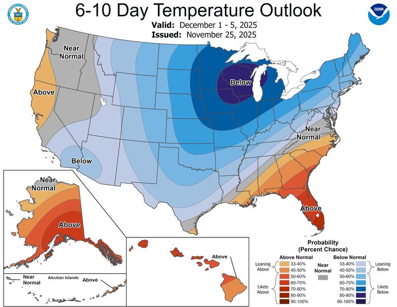
Meteorologists don't have the specific forecast ready yet, but there is a growing consensus that December will be a frigid one for parts of the United States.
The National Weather Service's Climate Prediction Center says colder-than-normal weather is most likely in the northern and northeastern United States, but some forecasters say a complex dance involving the polar vortex could send some of Earth's most extreme cold toward the United States.
"My thinking is that the cold the first week of December is the appetizer and the main course will be in mid-December," said climatologist Judah Cohen, a research scientist at MIT, in an email to USA TODAY.
Indeed, according to Cohen's computer model, "which I can credibly claim as the world's best – is predicting that the most expansive region of most likely extreme cold on Earth stretches from the Canadian Plains to the U.S. East Coast in the 3rd week of December."
As for snow, that remains a wild card, as the weather systems that produce snow typically can't be predicted more than a few days in advance. Suffice it to say that having cold air present is half of the battle.
Polar vortex on hold?
The main “polar vortex” load of very cold air will remain mostly locked up in Canada through the next 7-10 days, said Weather Trader meteorologist Ryan Maue in a Substack post. Maue continues to monitor the polar vortex intrusion risk into the Lower 48 into December.
Indeed, the complex dances of large-scale climate patterns far above our heads – which include the infamous polar vortex and a phenomenon known as "sudden stratospheric warming" – will determine the intensity and duration of the cold weather in the United States in December, Cohen said. But "I am conflicted about exactly what is happening with the polar vortex," he admitted.
How cold will it get?
Although the most extreme cold won't arrive until later in December, widespread and persistent below-average temperatures for this time of year can be expected for a wide expanse of the country from the western High Plains to the East Coast next week, with some near average conditions for the Southeast states and warmer over Florida, according to the National Weather Service.
The coldest anomalies for both highs and lows are forecast over the Midwest Monday Dec. 1 and Tuesday Dec. 2, with highs only in the 10s to middle 20s for many of these areas, and lows in the 0s getting down to northern Missouri and Illinois by Monday morning as the arctic airmass becomes established over the region.
Some subzero overnight lows are well within the realm of possibility from eastern Montana to North Dakota, the weather service said.
(This story was updated to meet our standards.)
This article originally appeared on USA TODAY: Some of Earth's most extreme cold may be headed for the US in December
Reporting by Doyle Rice, USA TODAY / USA TODAY
USA TODAY Network via Reuters Connect

 KRGV Rio Grande Valley
 Click2Houston
 WFAA
WFAA 101.5 KNUE
 ABC13
ABC13 KENS 5
 KVUE News
 KETK
KETK AlterNet