
 21Alive News
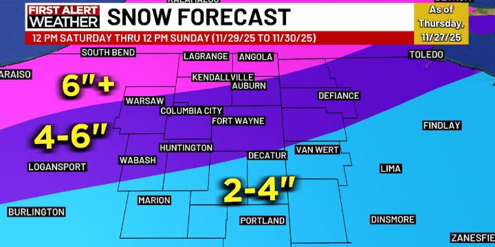
FORT WAYNE, Ind. (WPTA) - Lake effect snow showers will continue overnight and through midday Friday, resulting in some limited accumulation where these snow bands set up! They will likely be narrow and drop no more than an inch or two of fluffy snow:
WEEKEND WINTER STORM
Alright, let’s address the snowflake in the room! A WINTER STORM WATCH is in effect for all of Northeast Indiana and Northwest Ohio Saturday and Sunday. The watch will either be upgraded to a Winter Storm Warning (best chance of 6″+) or a lesser Winter Weather Advisory (more likely less than 6″). This determination will be made by the National Weather Service, likely tomorrow.
Snow is expected to begin between 10 am and noon Saturday, will likely be heaviest after 2p through 11p Saturday, and then potentially transitio

 IndyStar
 93 WIBC Indianapolis
 CBS4 Indy
 Newsweek Top
 Breitbart News
 YourTango Horoscope
 KCBD Sports
 Rockford Register Star Sports
 Fit&Well
 The Spectator