
 KIMT News 3
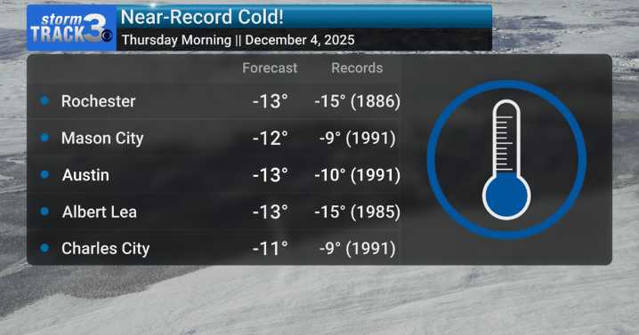
(KIMT) -- Thursday morning could be one for the record books! Thanks to a strong Canadian high pressure system surging southward over SE Minnesota and North Iowa, a clear sky will be present Wednesday night as winds relax from a breezy Wednesday.
The weather conditions will be prime for maximum radiational cooling, which is a process where heat from the surface escapes to space. This will allow temperatures to plummet to the -10s regionwide.
If you think this is awfully cold for this time of year, you would be right! In fact, we will be dealing with near-record low temperatures Thursday morning. Many locations could break records that have stood since the 1990s. One interesting note is Rochester, which will get close to an 1886 record!
A light northwestern breeze around sunrise Thursday

 Akron Beacon Journal
 Local News in New Jersey
 Daily Voice
 The radio station 99.5 The Apple
 KSNB Local4 Central Nebraska
 NBC 7 San Diego Local
 Associated Press US and World News Video
 The Oregonian Public Safety
 CNN Climate
 NECN Providence
 Slate Politics