
 KATC
KATC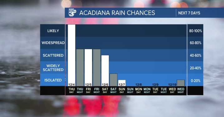
It’s been a chilly and dry few days, but that’s about to change! A coastal low is moving into the northern Gulf tonight, bringing widespread showers and a few isolated thunderstorms. While we don’t anticipate any severe weather, a couple of strong storms could develop.
Breyanna Lewis/KATC
Rainfall amounts are expected to be high, with most areas likely seeing between 1 and 4 inches, and isolated spots could receive 5 inches or more. Due to this forecast, we're under a marginal risk (1/5) for flash flooding.
Breyanna Lewis/KATC
Some models even suggest localized areas could see up to 11 inches of rain! If a flood watch is issued, please stay alert, as localized flooding, ponding, and minor street flooding are likely.
Breyanna Lewis/KATC
The heaviest rain will start after midnight and

 KSLA News
 KTAL-TV
 WDHN News
 WBTV Mecklenburg County
 WITN-TV
 ABC6 Rhode Island
 ABC11 WTVD
 York Dispatch
 WCCB Charlotte
 The Gaston Gazette
 WCCB Charlotte Crime
 New York Post Video
 Associated Press US News