
 USA TODAY National
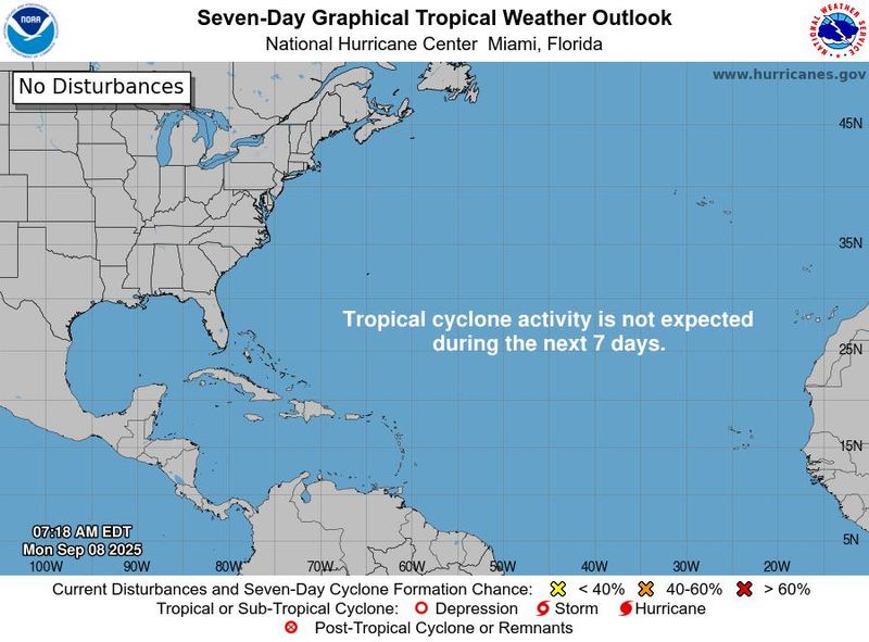
Where are all the hurricanes? So far, we've only had one in the Atlantic (Erin), a far cry from the predictions of as many as 10.
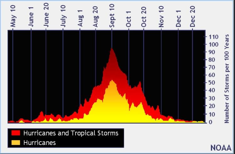
This week specifically is also usually quite active: Based on past years, Sept. 10 is the typical peak of the Atlantic hurricane season. But this year, a quiet week is expected instead, as no tropical cyclone formation is expected during the next seven days, according to the latest advisory from the National Hurricane Center released Sept. 8.
"Models show no areas of possible development this week, headed into the traditional hurricane season peak this Wednesday (Sept. 10)," said WPLG-TV hurricane specialist Michael Lowry in a Substack post.
Calling it a "ghost town," Weather Trader meteorologist Ryan Maue said in an e-mail to USA TODAY that "the Atlantic tropics have gone DORMANT again."
Why so quiet?
AccuWeather hurricane expert Alex DaSilva said “dry and dusty air will keep the Atlantic unusually quiet during the climatological peak of the hurricane season on Wednesday."
Among other factors, hurricanes don't form easily when tropical air is dry and dusty, forecasters said.
The Atlantic may stay quiet for the next 7-10 days, Maue said, or until a healthy enough tropical wave comes off Africa that can survive the otherwise hostile environmental conditions, which include dry air, high stability, dust and wind shear.
However, closer to home, with water temperatures in the Gulf running above the historical average, "any cluster of showers and thunderstorms that organize in the Gulf and along the southern Atlantic coast could evolve into a tropical storm, especially from mid- to late September," AccuWeather forecasters warned.
“A cold front off the Southeast coast could spin up some tropical development this weekend or early next week," DaSilva said. However, the risk of tropical development is low due to strong disruptive wind shear off the Southeast coast.”
Looking ahead
"The dry air and Saharan dust should start to clear out of the Atlantic main development region by this coming weekend," according to DaSilva. "Atmospheric conditions that are conducive to tropical development are expected to return in the second half of the month.”
Forecasters from Colorado State University were also more bullish on the prospects of storms later this month: In its two-week forecast for Sept. 3-16, Colorado State University forecasters predicted that activity will pick up over the next couple of weeks.
"Global model ensembles are pretty aggressive with additional tropical cyclone development in days 8 through 14, with potential formations in the eastern Atlantic as well as in the western Caribbean/southern Gulf," the CSU forecast said.
Were preseason forecasts wrong?
Most preseason forecasts called for an unusually active year, with as many as 19 named storms possible, including as many as 10 hurricanes, according to a forecast from the National Oceanic and Atmospheric Administration. So far, 6 named storms have formed, of which only one was a hurricane (Erin).
Maue said that "my forecast for this year is 14 named storms, 7 hurricanes, and 3 major hurricanes (near average) ... BUT that might be generous."
Andrew Hazelton, an associate scientist at the University of Miami’s Cooperative Institute for Marine and Atmospheric Studies, said on X Sept. 8 that "Given how quiet peak season has been and continues to be, it seems pretty likely this year will end up on the lower end of preseason forecasts."
"Outside of the flooding from early tropical storms and fringe impacts from Erin, it's been a low-impact year so far which would be really great if it continues," he said. "But there's a ways to go still."
This article originally appeared on USA TODAY: 'Ghost town': Atlantic goes quiet at typical peak of hurricane season
Reporting by Doyle Rice, USA TODAY / USA TODAY
USA TODAY Network via Reuters Connect

 America News
 Local News in Illinois
 The Tennessean
 FOX 13 Seattle King County
 FOX Weather
 Eyewitness News 3
 Lansing State Journal
 The Register-Guard
 Associated Press US and World News Video