
 USA TODAY National
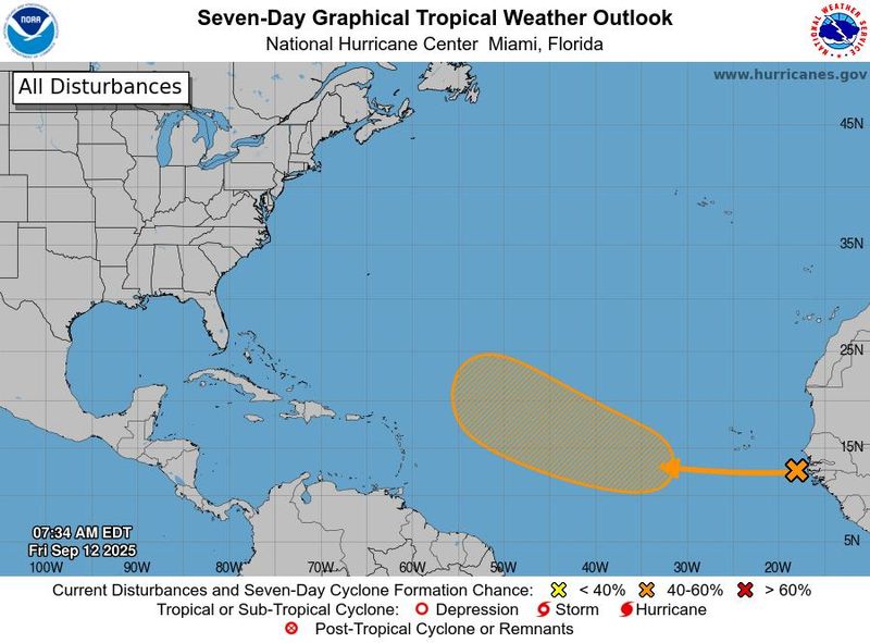
The typical peak of the Atlantic hurricane season has come and gone – and storms are still hard to come by, with only six reported so far this year. This is a bit below the average of eight and far from the seasonal predictions of up to 19.
A system off the African coast could become the seventh named storm (probably Tropical Storm Gabrielle) in the central Atlantic next week, but most signs are that the storm would stay out to sea even if it strengthens into a hurricane.
Meanwhile in the Pacific, a small Tropical Storm Mario should stay off the west coast of Mexico over the next few days.
Greetings Gabrielle?
The National Hurricane Center said Sept. 12 it's tracking a tropical wave located near the west coast of Africa that is producing "disorganized showers and thunderstorms."
"Environmental conditions appear conducive for some gradual development of this system over the next several days," the hurricane center said. "A tropical depression could form by the middle part of next week while it moves westward to west-northwestward at 10 to 15 mph over the eastern and central tropical Atlantic."
If the system gets a name, it would likely be Gabrielle.
Fortunately, concerns about the system are currently low: "This one doesn’t appear to be a threat to land over the next week," said WPLG-TV hurricane specialist Michael Lowry in a Substack post. "We’ll of course watch the trends for any southward shifts towards the islands, but odds favor a turn into the open Atlantic."
What's next in the Atlantic?
"Longer-term projections continue to support a more active Atlantic beyond next week," Lowry said.
"Models are advertising healthier disturbances rolling westward through the deep Atlantic to round out the month but for now it’s too soon to know what may come of these systems."
Weather Trader meteorologist Ryan Maue predicted "a more active Atlantic basin for sure, but thankfully everything looks to be recurving or staying away off the U.S. mainland."
Mario forms in Pacific
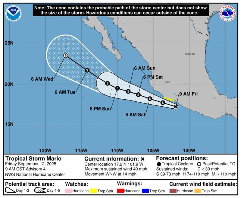
The hurricane center said that Tropical Storm Mario formed in the Pacific Ocean off the west coast of Mexico on Sept. 12. It's the 13th named storm of the 2025 eastern Pacific hurricane season.
Although some weather models show Mario reaching hurricane strength over the next few days, the official forecast from the hurricane center says it will remain a tropical storm.
The storm is moving toward the west-northwest near 14 mph and this general motion is expected to continue for the next couple of days. On the forecast track, the center of Mario is forecast to move parallel to, but offshore of, the southwestern coast of mainland Mexico through early Saturday, Sept. 13.
Forecasters said Mario could cause rainfall totals of 2 to 4 inches, with local amounts of 6 inches, across southern Mexico through Sunday, Sept. 14, bringing a risk of flash flooding, especially in areas of higher terrain.
As Mario moves along, it should lose wind intensity next week, AccuWeather said. However, it may help to send some tropical moisture northward into the U.S. Southwest.
"Some moisture may begin to show up in the form of clouds and spotty showers as early as Tuesday (Sept. 16) in parts of Southern California, Arizona and southern Nevada but are more likely from Wednesday (Sept. 17) on," AccuWeather senior meteorologist Heather Zehr said.
This article originally appeared on USA TODAY: Tropical trouble? Developing storms spin up in Atlantic and Pacific.
Reporting by Doyle Rice, USA TODAY / USA TODAY
USA TODAY Network via Reuters Connect

 America News
 Local News in Illinois
 The Tennessean
 FOX 13 Seattle King County
 FOX Weather
 Eyewitness News 3
 Lansing State Journal
 The Register-Guard
 Raw Story