
 USA TODAY National
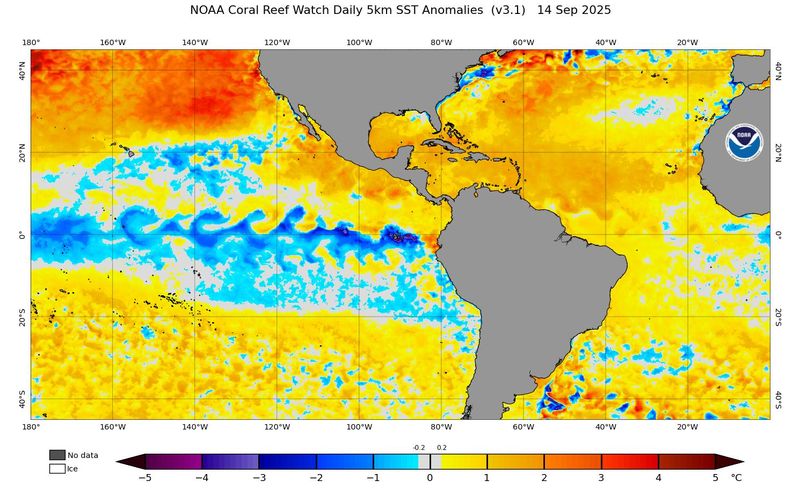
La Niña is coming, forecasters say.
Specifically, a La Niña is likely in the next couple of months, with a 71% chance between October and December, the Climate Prediction Center said on Sept. 11. With the forecast, the CPC also issued a "La Nina watch," which means conditions are favorable for the development of La Niña within the next six months.
The World Meteorological Organization, in a separate forecast released earlier this month, put the odds for a La Nina at 60%.
The shift could impact the tail end of the 2025 hurricane season, and also have an effect on fall and winter weather in the U.S.
What is La Niña?
La Niña is a part of a natural climate cycle officially known as El Niño – Southern Oscillation, called ENSO by scientists. The cycle swings between warmer and cooler seawater in a region along the equator in the tropical Pacific. La Niña is marked by cooler-than-average ocean water in the region.
It is one of the main drivers of weather in the U.S., especially during the late fall, winter and early spring. It's the opposite of the more well-known El Niño, which occurs when Pacific Ocean water is at least 0.9 degree warmer than average for three months.
The intermediate stage is known as ENSO-Neutral, when neither La Niña nor El Niño are present.
Weak and brief?
Signs point to a short-lived, potentially unremarkable event.
"If we get to a weak La Niña, it should be very brief and weak … all the models warm back to neutral by the end of the year," and a slow warming to near or above neutral conditions by late next spring, said Donald Keeney, agricultural meteorologist at Vaisala Weather.
How could it impact hurricane season?
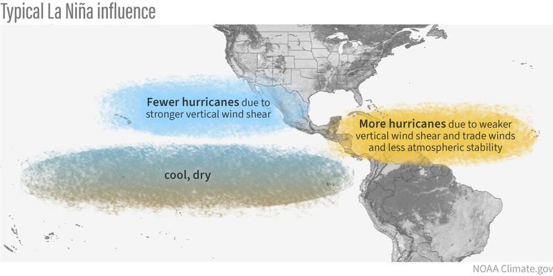
"The chances of La Niña conditions greatly increase late in the 2025 Atlantic hurricane season, especially in October and November," AccuWeather lead hurricane expert Alex DaSilva said in an online forecast. "This favors an active end to the hurricane season."
November storms could be affected, according to Matthew Rosencrans, lead hurricane seasonal forecaster with the National Oceanic and Atmospheric Administration. "La Niña conditions are associated with more activity (double the amount) in November when compared to ENSO Neutral and especially when compared to Novembers with El Niño conditions," he said in an e-mail to USA TODAY.
When a La Niña phase occurs, less wind shear occurs in the regions of the Atlantic basin where tropical weather develops, increasing the potential for more storms, AccuWeather said.
How will this La Niña impact our winter weather?
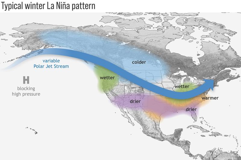
A typical La Niña winter in the United States brings cold and snow to the Northwest and unusually dry conditions to most of the Southern states, according to the Climate Prediction Center. The Southeast and mid-Atlantic also tend to see higher-than-average temperatures during a La Niña winter.
In the East, the northern branch of the jet stream tends to carry faster-moving, less intense storms, which can mean snowfall near or even below average, with temperatures closer to seasonal norms, AccuWeather said.
"However, predictions of this event are still uncertain, and indications point to a short-lived, weak event," Johnna Infanti, a seasonal forecaster with the Climate Prediction Center, told USA TODAY via email. "Weak and short-lived events tend to have less reliable impacts than strong, long-lived events," she added.
Contributing: Reuters
This article originally appeared on USA TODAY: Feds say La Niña is coming. What does this mean for hurricanes and our weather?
Reporting by Doyle Rice, USA TODAY / USA TODAY
USA TODAY Network via Reuters Connect

 America News
 Local News in Illinois
 The Tennessean
 FOX 13 Seattle King County
 FOX Weather
 Eyewitness News 3
 Lansing State Journal
 The Register-Guard
 Reuters US Top
 ABC News