
 WESH 2 News
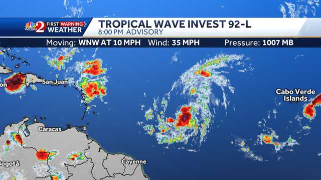
The National Hurricane Center is monitoring two areas in the Atlantic.
Tropical wave Invest 92-L Latest Forecast
° F FEELS LIKE
HOURLY
DAILY RADAR TRAFFIC
The tropical wave, designated as Invest 92-L, is located between the Windward Islands and the coast of West Africa and is producing showers and thunderstorms.
Dry and stable air could likely limit this system's development over the next few days, but a tropical depression or named storm could form by the middle to latter part of this week.
The system is expected to move west-northwestward at 10 to 15 mph over the central tropical Atlantic, the NHC said.
Related: Tracking Invest 92-L: Maps, path, spaghetti models
Formation chance through the next 48 hours: 90%
Formation chance through the next 7 days: 90%
At this t

 America News
 Local News in Illinois
 The Tennessean
 FOX 13 Seattle King County
 FOX Weather
 Eyewitness News 3
 Lansing State Journal
 The Register-Guard
 New York Post Video
 Grist
Grist