
 CBS4 Miami
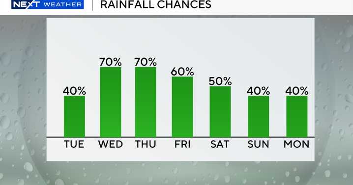
Big changes are ahead in South Florida and today will serve as the transition between the brief stretch of drier weather and the incoming rain.
High temperatures will climb to the upper 80s by Tuesday afternoon and scattered storms will develop later.
There is a moderate risk of rip currents along the Atlantic beaches and the UV index is very high. There are no alerts or advisories for boaters over the Atlantic waters and Keys waters.
The drier air above that has suppressed storm activity is in the process of being replaced by deeper moisture returning with a stalled out frontal boundary lifting north. This increase in atmospheric moisture across the region will result in higher coverage of showers and storms during the afternoon hours today as opposed to the sparser coverage from yeste

 ClickOrlando
 Local News in Illinois
 Ocala Star-Banner
 Week | 25 News Now
 FOX 5 Atlanta Crime
 Sweetwater Now
 FOX 13 Seattle King County
 The Columbian
 AccuWeather Severe Weather
 WSVN 7 News
 New York Post Video