
 USA TODAY National
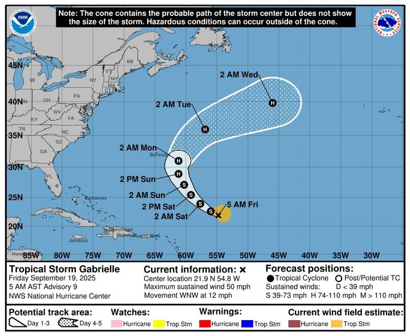
Tropical Storm Gabrielle continues to spin in the Atlantic and is expected to strengthen into a hurricane by the end of the weekend, according to the National Hurricane Center.
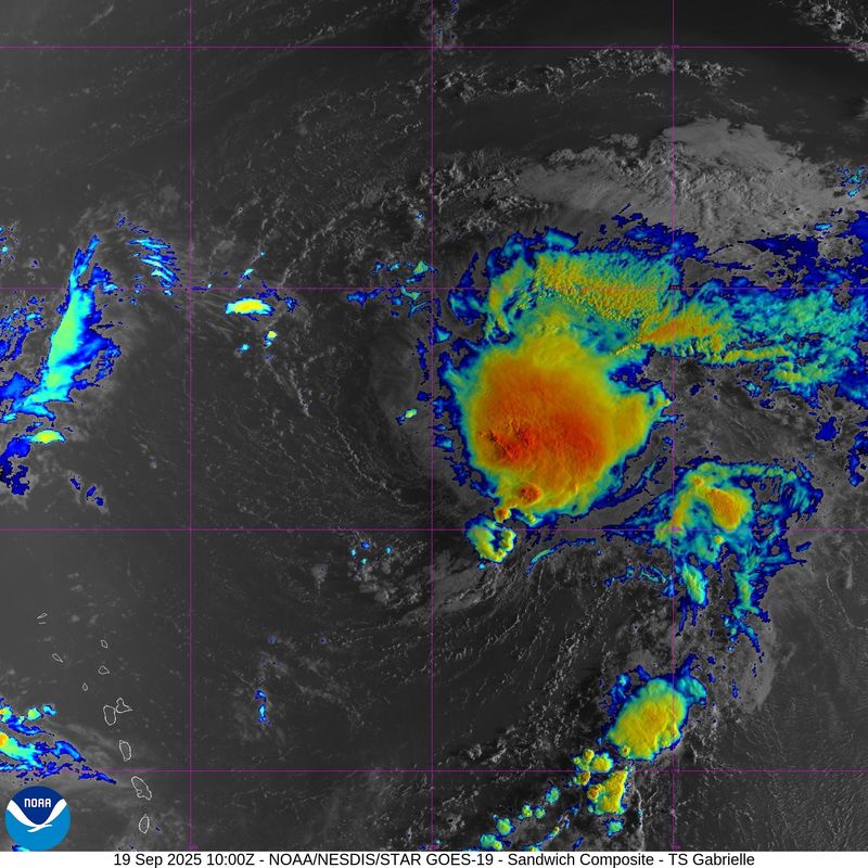
The hurricane center said in a Sept. 19 advisory that Gabrielle was centered about 915 miles southeast of Bermuda with maximum sustained winds near 50 mph with higher gusts. The storm has struggled to get it together, with a partially exposed center. However, forecasters expect "gradual strengthening," and Gabrielle is forecast to become a hurricane by Sunday, Sept. 21.
Gabrielle is moving toward the west-northwest at about 12 mph, with a gradual turn toward the northwest expected by Friday night, Sept. 19, followed by a north-northwestward turn by Saturday night, Sept. 20.
On the forecast track, the hurricane center said the center of Gabrielle is expected to pass east of Bermuda Sunday night and Monday, Sept. 22. Although the center of Gabrielle is expected to pass at least 160 miles east of Bermuda, the center advises island residents to continue to monitor the storm's progress because the average track error at 3 days is about 100 miles. For now, Bermuda has a 20%-25% chance of experiencing tropical storm-force winds.
Seas near the center of Gabrielle are running near 20 feet and are forecast to be as high as 28 feet by Sept. 22, according to the hurricane center's tropical analysis and forecast branch. The swells it's generating are forecast to reach Bermuda and build through the weekend, causing life-threatening surf and rip current conditions, the hurricane center said.
Gabrielle is forecast to remain at hurricane strength as it turns northeastward in the Atlantic by Tuesday, Sept. 23.
The hurricane center also is tracking a tropical wave off the western coast of Africa that forecasters say could slowly develop. For now, it has a 20% chance of formation through the next seven days.
Tropical Storm Gabrielle tracker
This forecast track shows the most likely path of the center of the storm. It does not illustrate the full width of the storm or its impacts, and the center of the storm is likely to travel outside the cone up to 33% of the time.
Tropical Storm Gabrielle spaghetti models
Illustrations include an array of forecast tools and models, and not all are created equal. The hurricane center uses only the top four or five highest-performing models to help make its forecasts.
NHC also keeping an eye on 2 systems in the Pacific
Meanwhile in the Eastern Pacific, the hurricane center is keeping tabs on two systems that could develop into tropical depressions in the coming days.
The first, labeled for tracking purposes as Invest 96L, is a few hundred miles south-southwest of the southern tip of the Baja California peninsula. Forecasters said in a Sept. 19 advisory this system "does not have a well-defined surface circulation."
However, a short-lived tropical depression could still form before the system encounters cooler sea surface temperatures and drier air, which will inhibit any further development, according to forecasters, who put development chances at 40%.
The hurricane center sees higher chances of development for the second system, a "large area of disorganized showers and thunderstorms" a few hundred miles south of the southern coast of Mexico. is associated with a trough of low pressure.
The hurricane center said environmental conditions appear conducive for some gradual development of this system, and a tropical depression could form by the middle of next week as it moves west-northwestward, roughly parallel to the coast of southern and southwestern Mexico. The center puts the chances of development over 48 hours at 30%, and the chances of development over the next 7 days at 70%.
See how Mario's remnant moisture washed over California
How do hurricanes form?
Hurricanes are born in the tropics, above warm water. Clusters of thunderstorms can develop over the ocean when water temperatures exceed 80 degrees. If conditions are right, the clusters swirl into a storm known as a tropical wave or tropical depression.
A tropical depression becomes a named tropical storm once its sustained wind speeds reach 39 mph. When its winds reach 74 mph, the storm officially becomes a hurricane.
Prepare now for hurricanes
Delaying potentially lifesaving preparations could mean waiting until it’s too late. "Get your disaster supplies while the shelves are still stocked, and get that insurance checkup early, as flood insurance requires a 30-day waiting period," the National Oceanic and Atmospheric Administration recommends.
- Develop an evacuation plan. If you are at risk from hurricanes, you need an evacuation plan. Now is the time to begin planning where you would go and how you would get there.
- Assemble disaster supplies. Whether you’re evacuating or sheltering in place, you’re going to need supplies not just to get through the storm but for a possibly lengthy aftermath, NOAA said.
- Get an insurance checkup and document your possessions. Contact your insurance company or agent now and ask for an insurance checkup to make sure you have enough insurance to repair or even replace your home and belongings. Remember, home and renters insurance don’t cover flooding, so you’ll need a separate policy for those. Flood insurance is available through your company, agent or the National Flood Insurance Program.
- Create a family communication plan. NOAA says you should take the time now to write down a hurricane plan and share it with your family. Determine family meeting places and make sure to include an out-of-town location in case of evacuation.
- Strengthen your home. Now is the time to improve your home’s ability to withstand hurricanes. Trim trees and install storm shutters, accordion shutters and impact glass, and seal outside wall openings.
Gabe Hauari is a national trending news reporter at USA TODAY. You can follow him on X @GabeHauari or email him at Gdhauari@gannett.com.
This article originally appeared on USA TODAY: Tropical Storm Gabrielle is expected to become a hurricane: See path
Reporting by Gabe Hauari, USA TODAY / USA TODAY
USA TODAY Network via Reuters Connect

 News Center MAINE
 WGRZ-TV
 Corpus Christi Caller-Times
 People Human Interest
 Florida Today
 FOX Weather
 Sarasota Herald-Tribune
 CBS News
 KY3
KY3 Los Angeles Times World
 Raw Story