
 KSNB Local4 Central Nebraska
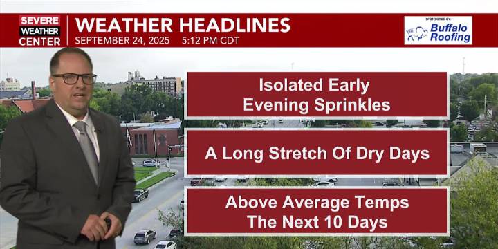
HASTINGS, Neb. (KSNB) - Good Wednesday evening everyone! Have had a few isolated pop-up showers this afternoon with the heating of the day. These will quickly dissipate around sunset and skies will gradually clear up tonight. Low temperatures tomorrow morning slide back to between the mid 40s west to the mid 50s east.
Tomorrow will begin a stretch of pleasantly warm and dry weather with lots of sunshine. There may be a few clouds between late Friday and early Saturday with the passage of a weak cool front. Look for a warm end to the week. Highs on Thursday will reach the upper 70s and low to mid 80s. Highs on Friday will more firmly be in the low to mid 80s. A small cool-down comes Saturday with highs in the upper 70s and lower 80s in the wake of the aforementioned cool front. Sunday look

 WAVE 3 News
 Sarasota Herald-Tribune
 FOX Weather
 WSAZ NewsChannel 3
 WVLT
WVLT Sky Sports Golf
 AlterNet
 FOX 13 Seattle Crime
 MLB
MLB