
 USA TODAY National
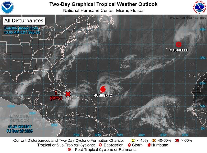
While Hurricane Humberto continues to strengthen out in the Atlantic Ocean and is forecast to become a major hurricane with wind speeds of 130 mph, it's not the storm that poses the most danger to U.S. shores.
No, the storm that U.S. residents have to worry most about isn't even a named storm yet, but is forecast to become Tropical Storm Imelda over the next few days.
And although Humberto is forecast to remain out to sea, it could still affect the path of soon-to-be Imelda through a meteorological process known as the Fujiwhara effect.
Indeed, how the storms interact with one another and with other weather systems in the region will determine the extent of impacts the storms could have on the U.S. East Coast, the Bahamas and potentially Bermuda over the next few days, but the risks are growing for impacts along the coast between Florida and North Carolina, National Hurricane Center director Michael Brennan said on the evening of Sept. 25.
What's the forecast for 94L?
"Showers and thunderstorms continue to show signs of organization in association with a tropical wave #94L located near Hispaniola and eastern Cuba," the hurricane center said on the morning of Sept. 26. "This low is expected to become a tropical depression near the central and northwest Bahamas over the weekend."
"While there remains considerable uncertainty in the long-range track and intensity of the system, there is a significant risk of wind, rainfall, and storm surge impacts for a portion of the southeast U.S. coast early next week," the hurricane center said.
In Charleston, South Carolina, National Weather Service meteorologist Blair Holloway said on the morning of Sept. 26 that confidence in the forecasts for the storm "has not increased or changed much from yesterday (Sept. 25)."
"Considerable uncertainty remains including its development, track, intensity, timing, and potential impacts," Holloway said.
Will it hit the US? Could it be another Helene?
"A majority of the (model) solutions, but not an overwhelming majority, bring the system toward the Carolinas by around Tuesday," said Houston-based meteorologist Matt Lanza on his Substack "the Eyewall" on Sept. 26. "However a non-trivial number of models peel the system back to the east, into the open Atlantic, due in part to some complex interactions with Hurricane Humberto."
"Anyone having confidence in what, precisely, will happen at this point is probably not being honest with themselves (or you)," he added.
Heavy rain might end up being the main calling card of Imelda. "There is real potential here for a rainmaker in the Carolinas, and particularly North Carolina," Lanza said. "Readers there will certainly and understandably be concerned that this could become another Hurricane Helene-like event. For now, we think that is unlikely, as the strongest rains appear to be east of areas most impacted by Helene, and the overall signal for prolonged, heavy rainfall is lower this time."
For now, he said, NOAA is predicting 6 to 10 inches of rainfall for areas hardest hit, which is no picnic, but also far from reaching Helene-levels.
Hurricane Humberto expected to be season's third major hurricane
At 11 a.m. on Sept. 26, Humberto was centered about 450 miles northeast of the northern Leewards and moving northwest at 5 mph, with sustained winds of 90 mph.
For now, Humberto is forecast to follow a pattern similar to Erin, moving between the U.S. and Bermuda, but the strengthening Humberto is increasing the risks of long period swells that could make seas and surf hazardous along the U.S. coast, the hurricane center said. Humberto's exact track is uncertain and remains tied to the future of the potential Imelda and other weather systems in the region.
Humberto is forecast to become a major hurricane with wind speeds of 145 mph, about 1,100 miles east-southeast of Miami by Sept. 28, the hurricane center said. If it does so, Colorado State University hurricane researcher Phil Klotzbach said the Atlantic would be "3 for 3" in hurricanes becoming major this year, with Erin and Gabrielle both becoming major hurricanes.
The last time an Atlantic hurricane season's first three hurricanes reached that level was in 1935, he said.
This article originally appeared on USA TODAY: Hurricane Humberto to explode into major hurricane, but forecasters have bigger worries
Reporting by Doyle Rice, USA TODAY / USA TODAY
USA TODAY Network via Reuters Connect

 CNN Video
 The Weather Channel
 America News
 WYFF Greenvile
 FOX 13 Tampa Bay Crime
 CourierPress
 Sarasota Herald-Tribune
 Associated Press US and World News Video
 The Fayetteville Observer
 Eyewitness News 3
 WWSB
WWSB Ocala Star-Banner
 OK Magazine