
 WDSU New Orleans
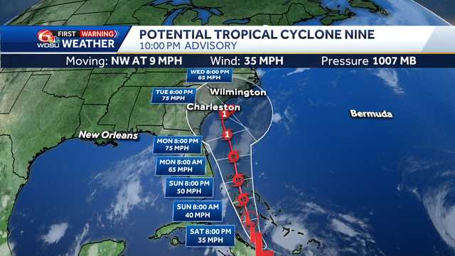
, —
POTENTIAL TROPICAL CYCLONE #9:
Invest 94-L was identified as Potential Tropical Cyclone #9 on Friday afternoon, located around southeast parts of Cuba and The Bahamas. It's moving northwest at 9 mph with maximum sustained winds of 35 mph. Advertisement
The storm is forecast to strengthen into a Tropical Storm and eventually a Hurricane. The system will be named, Imelda.
PTC#9 if eventually forecast to make landall across the southeastern U.S. by the middle to end of next week and could merge with an ordinary storm system and spin inland over the southeastern U.S. dropping several days of heavy rainfall, possibly over areas that were devstated by the leftovers of Hurricane Helene last year.
We will need to monitor the potential of high rainfall totalsover the region.
IMPACTS :
C

 WESH 2 News
 KCRA News
 WBKO
WBKO WAVE 3 News
 WHAS 11
 Raw Story
 TMZ
TMZ AlterNet