
 USA TODAY National
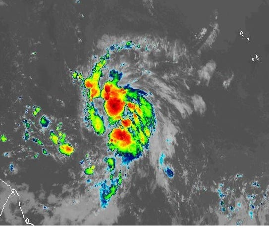
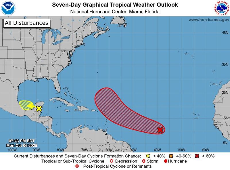
The National Hurricane Center expects a new tropical depression to form in the Atlantic Ocean "over the next day or so," and if it develops into the season's 10th named storm, it would be named Jerry.
Early on the morning of Oct. 7, the low pressure area likely to produce Jerry was about 1,500 miles east of the Windward Islands on the eastern end of the Caribbean Sea, said the National Hurricane Center.
Environmental conditions appear favorable for storm development, the hurricane center said. So far this season, the Atlantic Ocean's hurricane basin has produced four hurricanes and five tropical storms.
The area of disturbed weather likely to become Jerry is moving quickly west-northwestward across the central tropical Atlantic. In an early Oct. 7 forecast, the hurricane center put the chances of storm formation at 80% over 48 hours and 90% over seven days.
The area is forecast to be near or north of the northern Leeward Islands on Thursday, Oct. 9 and Friday, Oct. 10 and people there are urged to continue monitoring the storm's progress. Reconnaissance aircraft are scheduled to investigate the system on Wednesday, Oct. 8.
Many of the ensemble models used to forecast potential hurricane track indicate the system eventually could move off toward the north in the Atlantic as several other storms have done this season, but it's too soon to say for sure. Even if it does whirl out into the Atlantic, it could still send deadly and dangerous swells and hazardous surf and currents to the coast.
Already this season, nine houses have collapsed along the Outer Banks of North Carolina in rough surf and damaging waves as a pair of hurricanes, Humberto and Imelda, stirred up the ocean well offshore.
The hurricane center also is watching a disturbed area over the Bay of Campeche in the Southwestern Gulf of Mexico that has a minimal chance of formation but is forecast to bring heavy rains to portions of Belize, the Yucatan Peninsula and southern Mexico this week.
In the Eastern Pacific Ocean meanwhile, the basin is up to 16 named storms this season, inluding 10 hurricanes. Tropical Storm Octave (pronounced Oct tayv), formerly a hurricane, managed a complete u-turn and is headed eastward again, but it's expected to dissolve into a depression by late in the week.
Hurricane Priscilla is forecast to move along the western coast of Mexico, then make landfall along the Baja California coast by Friday, Oct. 10 as a tropical depression.
Where are the Pacific storms?
This forecast track shows the most likely path of the center of the storm. It does not illustrate the full width of the storm or its impacts, and the center of the storm is likely to travel outside the cone up to 33% of the time.
This article originally appeared on USA TODAY: Potential Tropical Storm Jerry could form soon in the Atlantic, forecasters say
Reporting by Dinah Voyles Pulver, USA TODAY / USA TODAY
USA TODAY Network via Reuters Connect

 Newsweek Top
 WKOW 27
 WBAL NewsRadio
 Local News in California
 KOLD Tucson
 NBC News
 Florida Today
 WIS News 10
 The Weather Channel
 AccuWeather Severe Weather
 FOX 10 Phoenix Latest
 IMDb TV