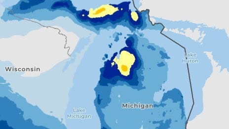
Some areas of Michigan could get 6-10 inches of lake-effect snow by Saturday, Dec. 13, with the rest of the state seeing lighter amounts, the National Weather Service says.
" A strong clipper system located over the Upper Midwest is forecast to pivot into the interior Northeast today (Dec. 10), ushering wintry weather and gusty winds into the region as it does so," the National Weather Service said.
Now until 7 a.m. Thursday, Dec. 11, the central to eastern Upper Peninsula and the northwest portion of the Lower Peninsula are expected to see the most snow accumulation in a 24-hour window, according to the National Weather Service's Probabilistic Precipitation Portal .
" Lake effect snow returns to the UP today (Dec. 10) through tomorrow (Dec. 11) for the north to northwest wind sno

 Detroit Free Press

 Battle Creek Enquirer
 ABC News
 ABC News Weather
 KOLR10 News
 KNOE
KNOE WAND TV
 NECN Providence
 KGNS
KGNS K2 Radio Local
 KXLH
KXLH CNN Politics