
 USA TODAY National
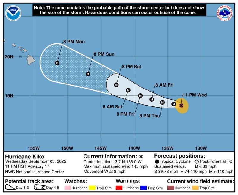
Hurricane Kiko is spinning over the Pacific Ocean as a major Category 4 storm on Sept. 4.
In an 11 a.m. ET update, the hurricane said the risk of direct impacts from wind and rainfall is increasing in the Hawaiian islands. Island residents and visitors are advised to monitor the storm's progress, but the center added it's "too soon to determine the exact location or magnitude of these impacts." There's a chance for heavy rainfall, flash flooding and increasingly dangerous surf conditions, according to the National Weather Service.
Hurricane Kiko could pass near Hawaii or make a direct hit to land, according to AccuWeather meteorologists.
"People across Hawaii should be prepared for several inches of rain and gusty winds from Kiko next week," said Alex DaSilva, AccuWeather lead hurricane expert. "There is a possible scenario that Kiko could bring strong winds and little rain, which could increase the risk of wildfires.”
As of 11 a.m. ET on Sept. 4, the National Hurricane Center said Kiko is located about 1,675 miles east-southeast of Honolulu with maximum sustained winds near 130 mph with higher gusts, making it a Category 4 hurricane on the Saffir-Simpson Hurricane Wind Scale. Kiko has weakened slightly, down from wind speeds of 145 mph, but remained a Category 4 and could re-intensify.
Fluctuations in intensity are forecast for Kiko during the next few days, the hurricane center said.
The NHC said Kiko is moving toward the west at around 9 mph, and this general motion is expected to continue through Thursday night, Sept. 4. A turn toward the west-northwest is expected on Sept. 5 with a gradual increase in forward speed expected over the weekend as Kiko approaches the Hawaiian Islands from the east.
There are currently no watches or warnings in effect stemming from Kiko, according to the hurricane center, however AccuWeather reports impacts to Hawaii are expected to begin by the middle of next week.
Residents and visitors to the islands should expect flooding downpours that may lead to mudslides and gusty winds that cause power outages and strong surf.
"The storm is expected to lose wind intensity over the weekend. If Kiko continues advancing toward Hawaii, it could bring some wind and rain impacts to the islands next week," DaSilva said.
Lorena, meanwhile, is expected to quickly weaken beginning Thursday, Sept. 4, while dumping several inches of rain across portions of the Baja California Sur, far southeast Baja California, and southwestern Sonora in Mexico, in addition to portions of Arizona and New Mexico through Saturday, Sept. 6, according to the hurricane center.
Storm tracker: Tracking path of Hurricane Kiko
This forecast track shows the most likely path of the center of the storm. It does not illustrate the full width of the storm or its impacts, and the center of the storm is likely to travel outside the cone up to 33% of the time.
Hurricane Kiko spaghetti models
Illustrations include an array of forecast tools and models, and not all are created equal. The hurricane center uses only the top four or five highest-performing models to help make its forecasts.
NHC also tracking a tropical wave in the Atlantic
In the Atlantic, the hurricane center is keeping tabs on a tropical wave located over the eastern tropical Atlantic, several hundred miles west-southwest of the Cabo Verde islands.
Forecasters said the showers and thunderstorms associated with this wave have started to consolidate and become slightly better organized, and that environmental conditions are conducive for gradual development of this system during the next several days. A tropical depression is likely to form late this week or this weekend, forecasters said in a Sept. 4 advisory.
The hurricane center said the system is likely to move faster toward the west or west-northwest afterwards and reach the waters east of the Lesser Antilles by the middle of next week, with forecasters giving the system an 80% chance of formation through the next seven days.
How do hurricanes form?
Hurricanes are born in the tropics, above warm water. Clusters of thunderstorms can develop over the ocean when water temperatures exceed 80 degrees. If conditions are right, the clusters swirl into a storm known as a tropical wave or tropical depression.
A tropical depression becomes a named tropical storm once its sustained wind speeds reach 39 mph. When its winds reach 74 mph, the storm officially becomes a hurricane.
Prepare now for hurricanes
Delaying potentially lifesaving preparations could mean waiting until it’s too late. "Get your disaster supplies while the shelves are still stocked, and get that insurance checkup early, as flood insurance requires a 30-day waiting period," the National Oceanic and Atmospheric Administration recommends.
- Develop an evacuation plan. If you are at risk from hurricanes, you need an evacuation plan. Now is the time to begin planning where you would go and how you would get there.
- Assemble disaster supplies. Whether you’re evacuating or sheltering in place, you’re going to need supplies not just to get through the storm but for a possibly lengthy aftermath, NOAA said.
- Get an insurance checkup and document your possessions. Contact your insurance company or agent now and ask for an insurance checkup to make sure you have enough insurance to repair or even replace your home and belongings. Remember, home and renters insurance don’t cover flooding, so you’ll need a separate policy for those. Flood insurance is available through your company, agent or the National Flood Insurance Program. Act now, because flood insurance requires a 30-day waiting period.
- Create a family communication plan. NOAA says you should take the time now to write down a hurricane plan and share it with your family. Determine family meeting places and make sure to include an out-of-town location in case of evacuation.
- Strengthen your home. Now is the time to improve your home’s ability to withstand hurricanes. Trim trees and install storm shutters, accordion shutters, and impact glass; seal outside wall openings.
Gabe Hauari is a national trending news reporter at USA TODAY. You can follow him on X @GabeHauari or email him at Gdhauari@gannett.com.
Contributing: Dinah Voyles Pulver, USA TODAY
This article originally appeared on USA TODAY: Powerful category 4 hurricane Kiko spins toward Hawaii. Is landfall in the forecast?
Reporting by Gabe Hauari and Jeanine Santucci, USA TODAY / USA TODAY
USA TODAY Network via Reuters Connect

 Columbia Daily Tribune
 America News
 Associated Press US News
 AccuWeather Severe Weather
 NBC News
 TownTimes news.com
 CBS News
 Reuters US Top
 Sun Sentinel
 Ars Technica Policy