
 USA TODAY National
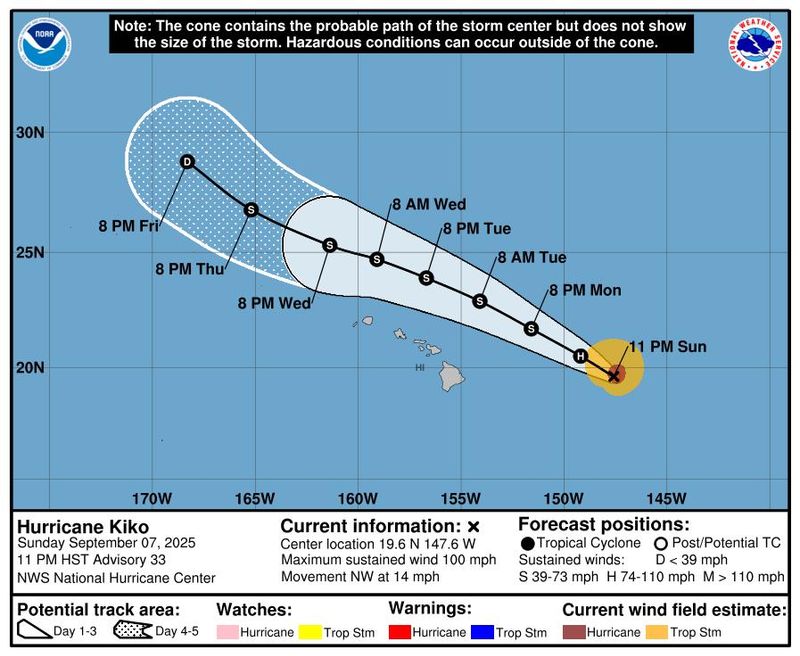
Hurricane Kiko remained a Category 1 hurricane on Monday, Sept. 8, continuing on a path forecast to skirt the north side of the Hawaiian Islands with the potential to cause life-threatening surf and rip current conditions.
According to the 11 a.m. HST advisory, Kiko was 350 miles east of Hilo, Hawaii, and about 515 miles east of Honolulu, Hawaii, the National Hurricane Center said. With maximum sustained winds estimated at 85 mph and higher gusts, it was moving northwest at 15 mph. An Air Force Reserve Hurricane Hunter flight investigated the storm earlier on the morning of Sept. 8.
Additional weakening is forecast during the next few days, with Kiko expected to become a tropical storm by late Monday, Sept. 8, forecasters said. The storm is expected to pass well north of the main Hawaiian Islands Tuesday and Wednesday, according to the hurricane center.
With the exception of surf, the risk of direct impacts to the Hawaiian Islands "continues to decrease," the National Weather Service said on Sept. 8. Chances of tropical storm force winds on any of the islands are less than 10%, according to the hurricane center's probability chart.
Swells generated by Kiko are forecast to gradually build, and peak along east-facing exposures of the Hawaiian Islands late Monday through midweek, potentially producing life-threatening surf and rip current conditions. An advisory for high surf of 10 feet or higher, or a warning for surf of 15 feet or higher, is likely overnight Monday for east-facing shores, the weather service said.
A tropical storm warning is in effect for Hawaiian offshore waters, from 40 nautical miles to 240 miles offshore, including the portion of the Papahanaumokuakea Marine National Monument east of French Frigate Shoals, the weather service said.
The hurricane center said interests in the Hawaiian Islands should monitor the progress of this storm.
Elsewhere, in the East Pacific Ocean, a tropical wave entering the Pacific from Central America has the potential to generate a low pressure area. It has a 50% chance of generating a tropical depression or storm over the next 7 days, the hurricane center said.
Hurricane Kiko path tracker
This forecast track shows the most likely path of the center of the storm. It does not illustrate the full width of the storm or its impacts, and the center of the storm is likely to travel outside the cone up to 33% of the time.
Hurricane Kiko spaghetti models
Illustrations include an array of forecast tools and models, and not all are created equal. The hurricane center uses only the top four or five highest-performing models to help make its forecasts.
How do hurricanes form?
Hurricanes are born in the tropics, above warm water. Clusters of thunderstorms can develop over the ocean when water temperatures exceed 80 degrees. If conditions are right, the clusters swirl into a storm known as a tropical wave or tropical depression.
A tropical depression becomes a named tropical storm once its sustained wind speeds reach 39 mph. When its winds reach 74 mph, the storm officially becomes a hurricane.
Prepare now for hurricanes
Delaying potentially lifesaving preparations could mean waiting until it’s too late. "Get your disaster supplies while the shelves are still stocked, and get that insurance checkup early, as flood insurance requires a 30-day waiting period," the National Oceanic and Atmospheric Administration recommends.
- Develop an evacuation plan. If you are at risk from hurricanes, you need an evacuation plan. Now is the time to begin planning where you would go and how you would get there.
- Assemble disaster supplies. Whether you’re evacuating or sheltering in place, you’re going to need supplies not just to get through the storm but for a possibly lengthy aftermath, NOAA said.
- Get an insurance checkup and document your possessions. Contact your insurance company or agent now and ask for an insurance checkup to make sure you have enough insurance to repair or even replace your home and belongings. Remember, home and renters insurance don’t cover flooding, so you’ll need a separate policy for those. Flood insurance is available through your company, agent or the National Flood Insurance Program. Act now, because flood insurance requires a 30-day waiting period.
- Create a family communication plan. NOAA says you should take the time now to write down a hurricane plan and share it with your family. Determine family meeting places and make sure to include an out-of-town location in case of evacuation.
- Strengthen your home. Now is the time to improve your home’s ability to withstand hurricanes. Trim trees and install storm shutters, accordion shutters and impact glass; seal outside wall openings.
Gabe Hauari is a national trending news reporter at USA TODAY. You can follow him on X @GabeHauari or email him at Gdhauari@gannett.com.
This article originally appeared on USA TODAY: Where is Hurricane Kiko headed? See path of the Category 1 storm.
Reporting by Gabe Hauari and Dinah Voyles Pulver, USA TODAY / USA TODAY
USA TODAY Network via Reuters Connect

 Associated Press US News
 KPBS News
 AccuWeather Severe Weather
 FOX 51 Gainesville Crime
 The Weather Channel
 IFL Science
 FOX 61 Weather
 Los Angeles Times
 The Gleaner