
 USA TODAY National
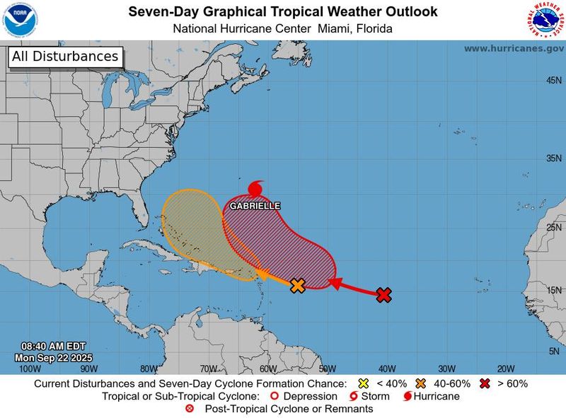
As Hurricane Gabrielle churns in the open Atlantic, forecasters are watching two tropical waves that could soon develop – signs the slow hurricane season is beginning to heat up.
The more organized of the two waves was located in the central Atlantic and was producing thunderstorms southwest of the Cabo Verde Islands. The other disturbance was centered 400 miles east of the Leeward Islands, according to a Sept. 22 update from the National Hurricane Center. Both seem poised for development, forecasters said.
"Looking at the satellite, the waves seem pretty juicy right now," said Alex DaSilva, lead hurricane expert for AccuWeather, adding, "This is the first time in a while that we're seeing multiple really healthy looking tropical waves."
The heightened storm activity comes during what has been a quiet 2025 Atlantic hurricane season. So far, there have been two hurricanes since the season began on June 1, including Gabrielle, now a Category 3 storm moving away from the U.S. coast, and Hurricane Erin in August.
Forecasters say the lull in storm activity was caused by wind shear as well as dry and dusty air. Those conditions appear to have waned, allowing waves off the coast of Africa to gain momentum as they move westward.
"Things look like they're really going to start picking up here in the Atlantic, and we're going to be making up for some lost ground," DaSilva said.
What are the chances that the tropical waves will develop?
The tropical wave between the Cabo Verde Islands and Lesser Antilles has a 70% chance of developing into a named storm over the next seven days, the hurricane center said in a Sept. 22 update.
Federal forecasters say the system could organize into a tropical depression by the middle to later part of this week as the system moves westward across the central Atlantic.
The other tropical wave is expected to experience little development until it reaches the warm waters near the Bahamas, where it could gain strength late this week.
“By the latter part of this week, the system is expected to slow down and turn more northwestward, and a tropical depression could form,” the hurricane center said, adding that the system has a 40% chance of formation over the next week.
One storm could prevent the other from developing
Speaking about the tropical waves moving west in the Atlantic, DaSilva said it's difficult for two storms to develop when they're in close proximity to one another.
"It's not common to get two storms really close together," he said. "It has happened, but what usually occurs is the dominant storm will make the environment of the other less favorable for development."
He added that the first storm to develop often imposes wind shear on the other, limiting its ability to strengthen. DaSilva noted, however, that both waves are expected to encounter more favorable conditions in the coming days.
"The waves look pretty good, so there is a shot at them both developing," DaSilva said.
Hurricane Gabrielle tracker
This forecast track shows the most likely path of the center of the storm. It does not illustrate the full width of the storm or its impacts, and the center of the storm is likely to travel outside the cone up to 33% of the time.
This article originally appeared on USA TODAY: Is hurricane season heating up? Forecasters track Gabrielle, 2 waves in the Atlantic
Reporting by Christopher Cann, USA TODAY / USA TODAY
USA TODAY Network via Reuters Connect

 NBC News
 News4JAX
 New York Post
 Associated Press US and World News Video
 CBS DFW
 Ocala Star-Banner
 KSNB Local4 Central Nebraska
 Democrat and Chronicle
 Hawaii News Now
 The Oregonian Public Safety
 NECN Providence
 The Star Press
 The US Sun Technology