
 USA TODAY National
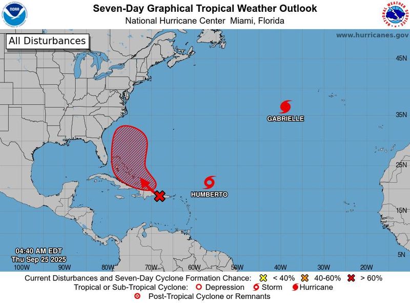
A pair of tropical systems continue to spin in the Atlantic basin on the morning of Sept. 25, their eventual fates highly uncertain, according to forecasters. One, Tropical Storm Humberto, formed late Sept. 24 in the southwestern Atlantic. The other, still a tropical wave, is meandering around the northeastern Caribbean Sea.
Both are capable of bringing impacts to the Caribbean, Bahamas and the southeastern U.S., according to AccuWeather meteorologist Alex Sosnowski.
"The interactions between these two systems will be highly complex and dependent on how each system behaves," Morgan Simms, a meteorologist with the National Weather Service in Morehead City, North Carolina said on the evening of Sept. 24. "Interactions like this in the Atlantic basin have little precedent – we don't have an appreciable historical record to draw reference to."
As of 11 a.m. ET Sept. 25, the center of Tropical Storm Humberto was located about 465 miles east-northeast of the Northern Leeward Islands. It had maximum sustained winds of 50 mph and was moving to the northwest at 8 mph.
Will a tropical cyclone impact the US in late September? Forecasters aren't sure yet.
So far, the ensemble models used by forecasters to predict the path of hurricanes are pretty united on a path northward for Humberto, although there are a few outliers that take it on a more westerly course.
The model ensembles are far more uncertain on the system over Puerto Rico and the Dominican Republic, indicating it could be a close call for Florida's east coast or put the U.S. Southeastern coast on alert.
The two systems might even interact through a process known as the Fujiwhara effect, forecasters said.
Roger Martin, a meteorologist with the National Weather Service office in Morehead City, North Carolina, reiterated the need for weather watchers to be careful with any of the hurricane model guidance they may encounter. "Because of the chaotic steering flow, a model run today may look vastly different than a run from the same model on a separate day," he said on the afternoon of Sep. 24.
Weather service offices are advising people to pay attention to the forecast into the weekend to be alert for any potential development.
Forecast uncertainty remains 'high'
Forecast uncertainty with the wave and Tropical Storm Humberto remains "high," the National Weather Service in Miami said on the morning of Sept. 25.
Several things make the forecast for the two storms offshore "tricky," wrote Andrew Hazelton, an associate scientist at the University of Miami's Cooperative Institute for Marine and Atmospheric Studies in a summary on Sept. 24.
Among the factors making the forecast so uncertain are the potential action with each other in a potential Fujiwhara effect, and their interaction with a front moving into the Southeast, as well as the potential effects of the system closest to shore moving over the mountainous regions of Hispaniola.
So far, Hazelton said, the new Google DeepMind ensemble, which has been impressing forecasters with its accuracy, is split on whether the closest system could recurve out into the ocean or make landfall somewhere along the Southeast coast.
Hurricane forecasters watch US weather patterns
Weather patterns over the Lower 48 are also playing a role in the forecast for the tropical systems: In Miami, the weather service said a cut-off low-pressure system over the Southeast is expected to push a frontal boundary toward South Florida then stall and dissipate north of Lake Okeechobee over the weekend and into early next week.
Meanwhile, there’s "a lot of uncertainty" with the tropical systems to the east with high chances for development and how they might interact with each other and the frontal boundary.
Will there be tropical cyclone impacts in Florida?
Along Central Florida's east coast, the weather service in Melbourne said a high risk of life-threatening rip currents remains along the beaches as long period swells from distant Hurricane Gabrielle continue to reach the coast, and advised small vessels to use caution.
Due to the tropical wave in the Northeast Caribbean, the weather service said it expects beach and boating conditions to deteriorate over the next seven days as the system moves toward the Bahamas. "It is too early to tell what if any other impacts East Central Florida could see," said meteorologist Robert Haley. "We recommend residents and visitors take this time to ensure their emergency plan is ready."
Hurricane hunter flights scheduled
At least a half-dozen hurricane hunter flights are scheduled for Sept. 25 and 26, so the hurricane center can keep an eye on the systems. Then, if a system develops from the wave moving into the Bahamas, additional flights would take place to get center position fixes every six hours, according to the reconnaissance schedule.
A rather quiet season … so far
So far this season, at eight named storms, 2025 is tied with 2024 for the fewest Atlantic named storms through Sept. 24 since 2014, said Phil Klotzbach, a senior research scientist at Colorado State University. However, he pointed out the 2024 season concluded with 18 named storms.
What about Hurricane Gabrielle?
Hurricane Gabrielle is zipping across the Atlantic at 32 mph about 535 miles west of the Azores. It's expected to cause hurricane conditions over the Azores by the morning of Sept. 26 and then begin transitioning to lose its tropical characteristics as it approaches the coast of Portugal over the weekend.
This article originally appeared on USA TODAY: September's hurricane forecast is historically uncertain. Is the US at risk?
Reporting by Doyle Rice, Dinah Voyles Pulver and Jeanine Santucci, USA TODAY / USA TODAY
USA TODAY Network via Reuters Connect

 Savannah Morning News
 News 19 WLTX
 WCBD News 2
 Asheville Citizen Times
 AccuWeather Severe Weather
 WRDW-TV News 12
 New York Post
 Ocala Star-Banner
 The Spokesman-Review
 The radio station 99.5 The Apple
 WCNC Charlotte Weather
 AlterNet