
 WLFI News 18
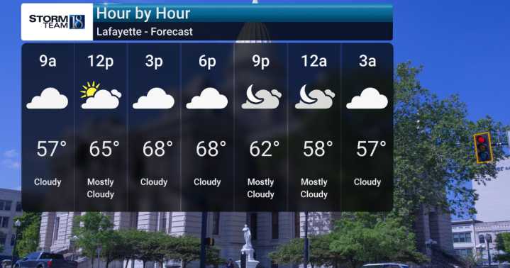
We've been enjoying warmer than normal temperatures, and that trend will continue through Friday. We're monitoring a high-pressure system that's going to keep things dry for us over the next few days, with highs generally in the 70s, and don't be surprised if we see some spots flirt with the 80-degree mark today. Tonight, expect clouds to increase early before they mix out, keeping overnight lows from getting too chilly, generally in the upper 40s to low 50s.
An active weather pattern that's expected to move in late Saturday and continue into Sunday with showers and possible thunderstorms developing, especially late Saturday into Sunday. This system means a significant change from our recent dry spell, bringing a good chance for rain and potentially some heavier downpours. There's even a

 WSIL-TV
 Queen City News
 WDHN News
 WBRC
WBRC KFOR
KFOR FOX 32 Chicago
 WNDU
WNDU WMUR TV
 WCNC Charlotte Weather
 PBS NewsHour Video
 WGNO
WGNO The Rink Live