
 21Alive News
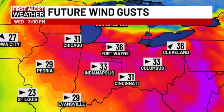
FORT WAYNE, Ind. (WPTA) - Strong wind was the main weather story today, and it’ll be the main weather story tomorrow! A large area of low pressure continues its trek eastward, but it’s currently overhead, so gusts of 30-40 mph+ look likely through the night and much of the day Wednesday.
With the passage of that low, wind will become westerly, meaning lake-effect rain will primarily affect western and southern Michigan, but our far northern communities (like Fremont, Angola, LaGrange, and perhaps Kendallville) could see some persistent showers as well. Everywhere else across Northern Indiana and Ohio, there will be more clouds than anything else. Highs everywhere will struggle much beyond the 50º mark.
Skies will try to clear Thursday, though some lake-effect clouds/shower activity could

 Hawaii News Now
 WTWO TV News
 FOX 59 Indianapolis Area Crime
 US Magazine Entertainment
 WBIW
WBIW NPR
NPR CNN Politics
 Breitbart News
 The Babylon Bee
 America News
 Atlanta Black Star Entertainment