
 Action News Now
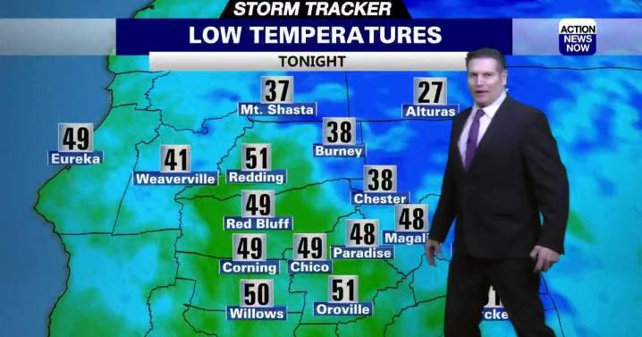
WHAT WE’RE TRACKING:
Breezy winds early in the week (mostly in the mountains) but heavy rain, heavy snow and strong winds arrive by Friday that carry through the weekend.
PLANNING YOUR NEXT 24 HOURS:
Sunny and warm (Light & Variable)
EXTENDED FORECAST:
Storms continue to move through the area through Monday (atmospheric river) from I-80 and to the north. These storms could bring heavy rain, strong winds and heavy mountain snow along with even cooler temperatures. The heaviest rain (and mountain snow) will take place further north in the valley along with the Sierra and Cascades mountains. Snow levels from Friday to Saturday will be around 8,000 feet. By late Saturday into Sunday, snow levels will drop down to 6,000 to 7,000 feet. Also, winds could be breezy over the weekend.
ACTIO

 4 News Now
 Local News in New York
 WAND TV
 Reuters US Top
 WWSB
WWSB FOX 13 Tampa Bay Crime
 NBC Connecticut
 AlterNet