
 KFVS12
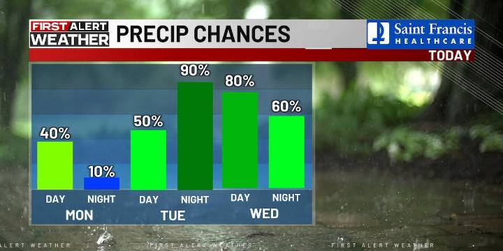
(KFVS) - Rain is slowly moving east of the Heartland this morning, but isolated showers will remain possible through the day.
Most of the region will stay dry, but cloudy and cool.
Highs will be in the upper 50s to low 60s.
Rain chances will ramp back up Tuesday night through Wednesday as an area of low pressure moves through on Tuesday.
Expect widespread rain, which could lead to another inch or two of rainfall across parts of the Heartland.
Stay tuned for updates on our First Alert Weather App .
Drier conditions arrive by the end of the week, but afternoon highs all week will stay on the cooler side in the 50s.
Halloween is trending dry with partly cloudy skies and lows in the 40s.

 Fox 26 Liberty County
 ABC13
ABC13 Community Impact Newspaper
 Associated Press US News
 CNN Crime and Justice
 FOX News
 FOX 26 Houston
 KICKS 105
 Breitbart News
 Raw Story